


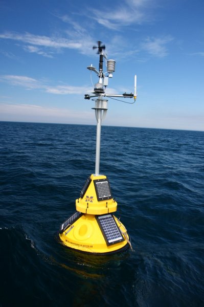
Station 45024 - Ludington Buoy, MI 
Owned and maintained by University of Michigan CIGLR
Moored Buoy
43.980 N 86.560 W (43°58'48" N 86°33'36" W)
Site elevation: 176 m above mean sea level
Air temp height: 2 m above site elevation
Anemometer height: 2 m above site elevation
Barometer elevation: 178 m above mean sea level
Sea temp depth: 1 m below water line
Water depth: 24 m
(24 hours for tsunami stations)
|
Click on the graph icon in the table below to see a time series plot of the last five days of that observation. | |
| S ( 190 deg true ) | |
| 5.8 kts | |
| 5.8 kts | |
| 1.3 ft | |
| 3 sec | |
| WSW ( 258 deg true ) | |
| 30.16 in | |
| 72.0 °F | |
| 68.5 °F | |
| 5.8 kts | |
| 5.8 kts | |
| TIME (EDT) |
WDIR |
WSPD kts |
GST kts |
WVHT ft |
DPD sec |
APD sec |
MWD |
PRES in |
PTDY in |
ATMP °F |
WTMP °F |
DEWP °F |
SAL psu |
VIS nmi |
TIDE ft |
|---|---|---|---|---|---|---|---|---|---|---|---|---|---|---|---|
| 2026-07-13 12:30 pm | SW | 5.8 | 7.8 | 1.3 | 3 | - | WSW | 30.16 | - | 72.9 | 68.5 | - | - | - | - |
| 2026-07-13 12:20 pm | SW | 7.8 | 9.7 | 1.3 | 3 | - | WSW | 30.16 | - | 72.7 | 68.4 | - | - | - | - |
| 2026-07-13 12:10 pm | SW | 7.8 | 9.7 | 1.3 | 3 | - | WSW | 30.16 | - | 72.5 | 68.4 | - | - | - | - |
| 2026-07-13 12:00 pm | SW | 7.8 | 9.7 | 1.3 | 3 | - | WSW | 30.16 | +0.00 | 72.3 | 68.0 | - | - | - | - |
| 2026-07-13 11:50 am | SSW | 5.8 | 7.8 | 1.3 | 3 | - | WSW | 30.16 | - | 72.3 | 67.6 | - | - | - | - |
| 2026-07-13 11:40 am | SW | 7.8 | 7.8 | 1.3 | 3 | - | WSW | 30.16 | - | 72.5 | 67.5 | - | - | - | - |
| 2026-07-13 11:30 am | SW | 7.8 | 7.8 | 1.3 | 3 | - | W | 30.16 | - | 72.9 | 67.3 | - | - | - | - |
| 2026-07-13 11:20 am | WSW | 7.8 | 9.7 | 1.3 | 3 | - | W | 30.16 | - | 72.1 | 67.1 | - | - | - | - |
| 2026-07-13 11:10 am | WSW | 7.8 | 9.7 | 1.3 | 3 | - | WSW | 30.16 | - | 71.6 | 66.9 | - | - | - | - |
| 2026-07-13 11:00 am | W | 7.8 | 7.8 | 1.3 | 3 | - | WSW | 30.16 | +0.01 | 71.8 | 66.9 | - | - | - | - |
| 2026-07-13 10:50 am | WSW | 5.8 | 9.7 | 1.6 | 3 | - | W | 30.16 | - | 72.0 | 67.1 | - | - | - | - |
| 2026-07-13 10:20 am | W | 7.8 | 9.7 | 1.6 | 3 | - | W | 30.17 | - | 71.4 | 67.3 | - | - | - | - |
| 2026-07-13 10:10 am | W | 7.8 | 7.8 | 1.3 | 3 | - | W | 30.17 | - | 71.8 | 67.6 | - | - | - | - |
| 2026-07-13 10:00 am | W | 9.7 | 9.7 | 1.3 | 3 | - | W | 30.17 | +0.02 | 72.1 | 67.8 | - | - | - | - |
| 2026-07-13 09:50 am | W | 9.7 | 9.7 | 1.3 | 3 | - | W | 30.16 | - | 72.3 | - | - | - | - | - |
| 2026-07-13 09:40 am | W | 7.8 | 9.7 | 1.3 | 3 | - | W | 30.16 | - | 72.0 | - | - | - | - | - |
| 2026-07-13 09:30 am | W | 5.8 | 9.7 | 1.6 | 3 | - | W | 30.16 | - | 72.0 | - | - | - | - | - |
| 2026-07-13 09:20 am | W | 7.8 | 7.8 | 1.6 | 3 | - | W | 30.16 | - | 72.1 | 68.0 | - | - | - | - |
| 2026-07-13 09:10 am | W | 7.8 | 9.7 | 1.6 | 3 | - | W | 30.16 | - | 72.1 | 68.0 | - | - | - | - |
| 2026-07-13 09:00 am | W | 9.7 | 9.7 | 1.6 | 3 | - | W | 30.16 | -0.04 | 72.1 | 68.0 | - | - | - | - |
| 2026-07-13 08:50 am | W | 11.7 | 13.6 | 1.6 | 3 | - | W | 30.15 | - | 72.0 | 68.0 | - | - | - | - |
| 2026-07-13 08:40 am | W | 13.6 | 15.5 | 1.6 | 3 | - | W | 30.15 | - | 72.0 | 68.0 | - | - | - | - |
| 2026-07-13 08:30 am | W | 13.6 | 17.5 | 1.3 | 3 | - | W | 30.15 | - | 72.0 | 68.4 | - | - | - | - |
| 2026-07-13 08:20 am | W | 15.5 | 17.5 | 1.3 | 3 | - | W | 30.15 | - | 72.0 | 68.7 | - | - | - | - |
| 2026-07-13 08:10 am | WSW | 15.5 | 17.5 | 1.3 | 3 | - | W | 30.15 | - | 71.8 | 68.9 | - | - | - | - |
| 2026-07-13 08:00 am | WSW | 15.5 | 17.5 | 1.3 | 3 | - | W | 30.15 | -0.04 | 71.6 | 69.1 | - | - | - | - |
| 2026-07-13 07:50 am | WSW | 15.5 | 17.5 | 1.3 | 3 | - | W | 30.15 | - | 71.8 | - | - | - | - | - |
| 2026-07-13 07:40 am | WSW | 15.5 | 17.5 | 1.3 | 3 | - | W | 30.15 | - | 72.0 | - | - | - | - | - |
| 2026-07-13 07:30 am | WSW | 15.5 | 17.5 | 1.0 | 4 | - | W | 30.14 | - | 72.0 | 69.6 | - | - | - | - |
| 2026-07-13 07:20 am | SW | 15.5 | 17.5 | 1.0 | 4 | - | W | 30.14 | - | 72.0 | 69.8 | - | - | - | - |
| 2026-07-13 07:10 am | SW | 13.6 | 15.5 | 1.0 | 3 | - | W | 30.15 | - | 71.6 | 69.8 | - | - | - | - |
| 2026-07-13 07:00 am | SSW | 13.6 | 17.5 | 1.0 | 3 | - | W | 30.14 | -0.05 | 71.4 | 70.0 | - | - | - | - |
| 2026-07-13 06:50 am | SSW | 11.7 | 13.6 | 1.0 | 4 | - | W | 30.16 | - | 71.2 | 70.0 | - | - | - | - |
| 2026-07-13 06:40 am | S | 11.7 | 13.6 | 1.0 | 4 | - | W | 30.17 | - | 71.2 | 69.8 | - | - | - | - |
| 2026-07-13 06:30 am | S | 11.7 | 13.6 | 1.0 | 3 | - | WSW | 30.19 | - | 71.2 | 69.8 | - | - | - | - |
| 2026-07-13 06:20 am | SSE | 9.7 | 9.7 | 1.0 | 3 | - | WSW | 30.21 | - | 71.4 | 69.6 | - | - | - | - |
| 2026-07-13 06:10 am | SSE | 7.8 | 9.7 | 1.0 | 3 | - | SW | 30.21 | - | 71.4 | 69.6 | - | - | - | - |
| 2026-07-13 06:00 am | S | 7.8 | 7.8 | 1.0 | 3 | - | SW | 30.19 | +0.03 | 71.2 | 69.6 | - | - | - | - |
| 2026-07-13 05:50 am | S | 7.8 | 9.7 | 1.0 | 4 | - | SW | 30.19 | - | 71.4 | 69.6 | - | - | - | - |
| 2026-07-13 05:40 am | S | 9.7 | 11.7 | 1.0 | 4 | - | SW | 30.18 | - | 71.2 | 69.8 | - | - | - | - |
| 2026-07-13 05:30 am | SSE | 7.8 | 9.7 | 1.0 | 4 | - | WSW | 30.19 | - | 71.1 | 70.0 | - | - | - | - |
| 2026-07-13 05:20 am | SSE | 5.8 | 5.8 | 1.0 | 4 | - | WSW | 30.20 | - | 71.6 | 70.2 | - | - | - | - |
| 2026-07-13 05:10 am | S | 5.8 | 5.8 | 1.0 | 4 | - | WSW | 30.19 | - | 71.8 | 70.3 | - | - | - | - |
| 2026-07-13 05:00 am | S | 3.9 | 5.8 | 1.0 | 4 | - | WSW | 30.19 | +0.02 | 72.0 | 70.3 | - | - | - | - |
| 2026-07-13 04:50 am | SSW | 3.9 | 5.8 | 1.0 | 3 | - | WSW | 30.19 | - | 72.0 | 70.3 | - | - | - | - |
| 2026-07-13 04:40 am | SSW | 3.9 | 5.8 | 1.0 | 3 | - | WSW | 30.19 | - | 71.6 | 70.5 | - | - | - | - |
| 2026-07-13 04:30 am | S | 3.9 | 5.8 | 1.0 | 3 | - | WSW | 30.19 | - | 71.2 | 70.7 | - | - | - | - |
| 2026-07-13 04:20 am | S | 3.9 | 5.8 | 1.0 | 3 | - | WSW | 30.19 | - | 71.2 | 70.7 | - | - | - | - |
| 2026-07-13 04:10 am | S | 3.9 | 3.9 | 1.0 | 3 | - | WSW | 30.19 | - | 71.4 | 70.9 | - | - | - | - |
| 2026-07-13 04:00 am | S | 1.9 | 3.9 | 1.0 | 3 | - | WSW | 30.19 | +0.03 | 71.6 | 71.1 | - | - | - | - |
| 2026-07-13 03:50 am | SE | 1.9 | 3.9 | 1.3 | 3 | - | W | 30.19 | - | 71.6 | 71.1 | - | - | - | - |
| 2026-07-13 03:40 am | S | 3.9 | 3.9 | 1.3 | 3 | - | W | 30.19 | - | 71.6 | 71.1 | - | - | - | - |
| 2026-07-13 03:30 am | S | 5.8 | 5.8 | 1.0 | 3 | - | WSW | 30.17 | - | 71.4 | 71.1 | - | - | - | - |
| 2026-07-13 03:20 am | S | 5.8 | 5.8 | 1.0 | 3 | - | WSW | 30.17 | - | 71.8 | 71.1 | - | - | - | - |
| 2026-07-13 03:10 am | S | 5.8 | 7.8 | 1.0 | 3 | - | WSW | 30.17 | - | 72.0 | 71.2 | - | - | - | - |
| 2026-07-13 03:00 am | S | 5.8 | 7.8 | 1.0 | 3 | - | WSW | 30.17 | +0.02 | 72.1 | 71.2 | - | - | - | - |
| 2026-07-13 02:50 am | S | 5.8 | 7.8 | 1.0 | 3 | - | WSW | 30.17 | - | 72.0 | 71.2 | - | - | - | - |
| 2026-07-13 02:40 am | S | 5.8 | 7.8 | 1.0 | 3 | - | WSW | 30.17 | - | 71.6 | 71.2 | - | - | - | - |
| 2026-07-13 02:30 am | S | 7.8 | 9.7 | 1.0 | 3 | - | W | 30.16 | - | 71.6 | 71.2 | - | - | - | - |
| 2026-07-13 02:20 am | SSE | 7.8 | 9.7 | 1.0 | 3 | - | W | 30.17 | - | 71.4 | 71.1 | - | - | - | - |
| 2026-07-13 02:10 am | SSE | 5.8 | 7.8 | 1.0 | 3 | - | WSW | 30.17 | - | 72.0 | 71.1 | - | - | - | - |
| 2026-07-13 02:00 am | SSE | 5.8 | 7.8 | 1.0 | 3 | - | WSW | 30.18 | +0.04 | 72.0 | 71.1 | - | - | - | - |
| 2026-07-13 01:50 am | S | 5.8 | 7.8 | 1.0 | 3 | - | WSW | 30.17 | - | 71.8 | 70.7 | - | - | - | - |
| 2026-07-13 01:40 am | SSE | 5.8 | 7.8 | 1.0 | 3 | - | WSW | 30.16 | - | 71.6 | 71.1 | - | - | - | - |
| 2026-07-13 01:30 am | S | 5.8 | 7.8 | 0.7 | - | - | WSW | 30.16 | - | 72.1 | 71.1 | - | - | - | - |
| 2026-07-13 01:20 am | S | 7.8 | 9.7 | 0.7 | - | - | WSW | 30.16 | - | 72.3 | 71.1 | - | - | - | - |
| 2026-07-13 01:10 am | S | 7.8 | 9.7 | 0.7 | - | - | W | 30.16 | - | 72.1 | 70.7 | - | - | - | - |
| 2026-07-13 01:00 am | S | 5.8 | 7.8 | 0.7 | - | - | W | 30.16 | +0.07 | 71.6 | 70.5 | - | - | - | - |
| 2026-07-13 12:50 am | S | 5.8 | 5.8 | 1.0 | 2 | - | WSW | 30.16 | - | 71.1 | 70.3 | - | - | - | - |
| 2026-07-13 12:40 am | S | 3.9 | 5.8 | 1.0 | 2 | - | WSW | 30.16 | - | 71.1 | 70.2 | - | - | - | - |
| 2026-07-13 12:30 am | S | 3.9 | 5.8 | 1.0 | 2 | - | WSW | 30.16 | - | 71.1 | 69.6 | - | - | - | - |
| 2026-07-13 12:20 am | S | 3.9 | 5.8 | 1.0 | 2 | - | WSW | 30.15 | - | 71.2 | 69.3 | - | - | - | - |
| 2026-07-13 12:10 am | SSW | 3.9 | 5.8 | 1.0 | 2 | - | WSW | 30.15 | - | 71.4 | 68.7 | - | - | - | - |
| 2026-07-13 12:00 am | SSW | 3.9 | 5.8 | 1.0 | 2 | - | WSW | 30.15 | +0.00 | 71.2 | 68.5 | - | - | - | - |
| 2026-07-12 11:50 pm | SSW | 3.9 | 5.8 | 1.0 | 2 | - | WSW | 30.15 | - | 71.2 | 68.7 | - | - | - | - |
| 2026-07-12 11:40 pm | SSW | 5.8 | 7.8 | 1.0 | 2 | - | WSW | 30.15 | - | 71.6 | 68.9 | - | - | - | - |
| 2026-07-12 11:30 pm | SW | 3.9 | 5.8 | 1.0 | 2 | - | WSW | 30.15 | - | 71.4 | 69.3 | - | - | - | - |
| 2026-07-12 11:20 pm | SW | 3.9 | 5.8 | 1.0 | 2 | - | W | 30.14 | - | 71.4 | 69.4 | - | - | - | - |
| 2026-07-12 11:10 pm | SW | 7.8 | 9.7 | 1.0 | 2 | - | W | 30.14 | - | 71.4 | 70.0 | - | - | - | - |
| 2026-07-12 11:00 pm | SW | 7.8 | 7.8 | 1.0 | 2 | - | WSW | 30.14 | -0.09 | 71.6 | 69.8 | - | - | - | - |
| 2026-07-12 10:50 pm | SW | 3.9 | 5.8 | 1.0 | 2 | - | WSW | 30.15 | - | 72.0 | 69.1 | - | - | - | - |
| 2026-07-12 10:40 pm | SW | 5.8 | 7.8 | 0.7 | - | - | WSW | 30.15 | - | 72.3 | 68.9 | - | - | - | - |
| 2026-07-12 10:30 pm | SW | 11.7 | 15.5 | 0.7 | - | - | WSW | 30.11 | - | 72.0 | 68.9 | - | - | - | - |
| 2026-07-12 10:20 pm | SSW | 11.7 | 13.6 | 0.7 | - | - | WSW | 30.11 | - | 71.8 | 68.7 | - | - | - | - |
| 2026-07-12 10:10 pm | SW | 11.7 | 13.6 | 0.7 | - | - | WSW | 30.11 | - | 72.0 | 68.5 | - | - | - | - |
| 2026-07-12 10:00 pm | SW | 15.5 | 19.4 | 0.3 | - | - | SW | 30.09 | -0.11 | 71.6 | 69.1 | - | - | - | - |
| 2026-07-12 09:50 pm | SW | 15.5 | 15.5 | 0.3 | - | - | SW | 30.10 | - | 71.8 | 68.9 | - | - | - | - |
| 2026-07-12 09:40 pm | SW | 11.7 | 13.6 | 0.3 | - | - | - | 30.11 | - | 72.0 | 67.8 | - | - | - | - |
| 2026-07-12 09:30 pm | SW | 9.7 | 13.6 | 0.3 | - | - | - | 30.12 | - | 72.0 | 68.2 | - | - | - | - |
| 2026-07-12 09:20 pm | SW | 9.7 | 11.7 | 0.3 | - | - | SW | 30.13 | - | 72.1 | 66.7 | - | - | - | - |
| 2026-07-12 09:10 pm | SSW | 7.8 | 9.7 | 0.3 | - | - | SW | 30.14 | - | 72.1 | 66.4 | - | - | - | - |
| 2026-07-12 09:00 pm | S | 7.8 | 7.8 | 0.3 | - | - | SW | 30.14 | -0.04 | 72.0 | 67.8 | - | - | - | - |
| 2026-07-12 08:50 pm | SSE | 5.8 | 5.8 | 0.3 | - | - | SW | 30.16 | - | 72.0 | 66.9 | - | - | - | - |
| 2026-07-12 08:40 pm | S | 3.9 | 5.8 | 0.0 | - | - | SSW | 30.18 | - | 71.8 | 62.1 | - | - | - | - |
| 2026-07-12 08:30 pm | S | 3.9 | 3.9 | 0.0 | - | - | SSW | 30.19 | - | 72.3 | 66.7 | - | - | - | - |
| 2026-07-12 08:20 pm | E | 1.9 | 1.9 | 0.3 | - | - | SW | 30.21 | - | 72.7 | 66.6 | - | - | - | - |
| 2026-07-12 08:10 pm | NE | 3.9 | 3.9 | 0.3 | - | - | SW | 30.23 | - | 71.8 | 67.3 | - | - | - | - |
| 2026-07-12 08:00 pm | NE | 3.9 | 3.9 | 0.3 | - | - | SW | 30.23 | +0.05 | 71.6 | 68.4 | - | - | - | - |
| 2026-07-12 07:50 pm | NE | 3.9 | 5.8 | 0.3 | - | - | W | 30.22 | - | 71.8 | 68.7 | - | - | - | - |
| 2026-07-12 07:40 pm | NE | 3.9 | 3.9 | 0.3 | - | - | W | 30.22 | - | 71.8 | - | - | - | - | - |
| 2026-07-12 07:30 pm | ENE | 3.9 | 3.9 | 0.3 | - | - | WSW | 30.22 | - | 71.8 | 69.1 | - | - | - | - |
| 2026-07-12 07:20 pm | NE | 3.9 | 3.9 | 0.3 | - | - | WSW | 30.21 | - | 71.8 | 64.2 | - | - | - | - |
| 2026-07-12 07:10 pm | NE | 1.9 | 3.9 | 0.3 | - | - | WSW | 30.21 | - | 72.1 | 69.3 | - | - | - | - |
| 2026-07-12 07:00 pm | SE | 1.9 | 1.9 | 0.3 | - | - | WSW | 30.19 | +0.00 | 72.3 | 67.6 | - | - | - | - |
| 2026-07-12 06:50 pm | ENE | 1.9 | 1.9 | 0.3 | - | - | SW | 30.20 | - | 72.9 | 66.2 | - | - | - | - |
| 2026-07-12 06:40 pm | ENE | 1.9 | 1.9 | 0.3 | - | - | SW | 30.20 | - | 72.7 | 65.7 | - | - | - | - |
| 2026-07-12 06:30 pm | ENE | 3.9 | 5.8 | 0.3 | - | - | SW | 30.20 | - | 72.1 | 66.4 | - | - | - | - |
| 2026-07-12 06:20 pm | N | 1.9 | 3.9 | 0.3 | - | - | SW | 30.20 | - | 73.6 | 61.2 | - | - | - | - |
| 2026-07-12 06:10 pm | W | 1.9 | 1.9 | 0.3 | - | - | SW | 30.20 | - | 73.2 | 65.8 | - | - | - | - |
| 2026-07-12 06:00 pm | WSW | 1.9 | 3.9 | 0.3 | - | - | SW | 30.19 | -0.05 | 72.3 | 60.8 | - | - | - | - |
| 2026-07-12 05:50 pm | SW | 3.9 | 5.8 | 0.3 | - | - | SSW | 30.18 | - | 72.0 | 61.5 | - | - | - | - |
| 2026-07-12 05:40 pm | SW | 5.8 | 5.8 | 0.3 | - | - | SSW | 30.17 | - | 71.8 | 65.7 | - | - | - | - |
| 2026-07-12 05:30 pm | SW | 5.8 | 7.8 | 0.3 | - | - | SSW | 30.16 | - | 71.8 | 60.8 | - | - | - | - |
| 2026-07-12 05:20 pm | SSW | 5.8 | 7.8 | 0.3 | - | - | SSW | 30.17 | - | 71.8 | 65.8 | - | - | - | - |
| 2026-07-12 05:10 pm | SSW | 5.8 | 5.8 | 0.3 | - | - | SW | 30.18 | - | 71.8 | 65.3 | - | - | - | - |
| 2026-07-12 05:00 pm | SSW | 5.8 | 5.8 | 0.3 | - | - | SW | 30.18 | -0.07 | 71.8 | 66.2 | - | - | - | - |
| 2026-07-12 04:50 pm | SW | 5.8 | 7.8 | 0.3 | - | - | SE | 30.18 | - | 71.8 | 61.7 | - | - | - | - |
| 2026-07-12 04:40 pm | SSW | 5.8 | 5.8 | 0.3 | - | - | SE | 30.18 | - | 71.8 | 65.5 | - | - | - | - |
| 2026-07-12 04:30 pm | SW | 5.8 | 5.8 | 0.3 | - | - | SSE | 30.19 | - | 71.8 | 65.3 | - | - | - | - |
| 2026-07-12 04:20 pm | SSW | 5.8 | 5.8 | 0.3 | - | - | SSE | 30.19 | - | 71.8 | 65.1 | - | - | - | - |
| 2026-07-12 04:10 pm | SSW | 5.8 | 7.8 | 0.3 | - | - | SSE | 30.19 | - | 71.8 | 65.1 | - | - | - | - |
| 2026-07-12 04:00 pm | SSW | 5.8 | 7.8 | 0.3 | - | - | SSE | 30.19 | -0.05 | 71.8 | 65.1 | - | - | - | - |
| 2026-07-12 03:50 pm | SSW | 5.8 | 7.8 | 0.3 | - | - | S | 30.19 | - | 71.8 | 64.9 | - | - | - | - |
| 2026-07-12 03:40 pm | SSW | 5.8 | 7.8 | 0.3 | - | - | S | 30.20 | - | 71.8 | 64.9 | - | - | - | - |
| 2026-07-12 03:30 pm | SSW | 3.9 | 5.8 | 0.3 | - | - | S | 30.21 | - | 72.0 | 64.9 | - | - | - | - |
| 2026-07-12 03:20 pm | SW | 3.9 | 3.9 | 0.3 | - | - | S | 30.23 | - | 72.1 | 65.1 | - | - | - | - |
| 2026-07-12 03:10 pm | SW | 1.9 | 3.9 | 0.3 | - | - | SE | 30.24 | - | 72.1 | 65.5 | - | - | - | - |
| 2026-07-12 03:00 pm | SW | 1.9 | 3.9 | 0.3 | - | - | SE | 30.24 | -0.01 | 72.0 | 65.3 | - | - | - | - |
| 2026-07-12 02:50 pm | WSW | 3.9 | 3.9 | 0.3 | - | - | SSE | 30.24 | - | 71.8 | 65.3 | - | - | - | - |
| 2026-07-12 02:40 pm | WSW | 3.9 | 3.9 | 0.3 | - | - | SSE | 30.24 | - | 71.8 | 65.3 | - | - | - | - |
| 2026-07-12 02:30 pm | SW | 3.9 | 3.9 | 0.3 | - | - | S | 30.24 | - | 71.8 | 65.5 | - | - | - | - |
| 2026-07-12 02:20 pm | W | 1.9 | 1.9 | 0.3 | - | - | S | 30.24 | - | 71.8 | 65.5 | - | - | - | - |
| 2026-07-12 02:10 pm | W | 1.9 | 1.9 | 0.3 | - | - | S | 30.25 | - | 71.4 | 65.7 | - | - | - | - |
| 2026-07-12 02:00 pm | W | 1.9 | 3.9 | 0.3 | - | - | S | 30.25 | +0.00 | 71.2 | 66.2 | - | - | - | - |
| 2026-07-12 01:50 pm | SE | 3.9 | 3.9 | 0.3 | - | - | SE | 30.24 | - | 71.2 | 66.6 | - | - | - | - |
| 2026-07-12 01:40 pm | SSW | 3.9 | 3.9 | 0.3 | - | - | SE | 30.24 | - | 71.4 | 66.9 | - | - | - | - |
| 2026-07-12 01:30 pm | WSW | 3.9 | 3.9 | 0.3 | - | - | ESE | 30.24 | - | 71.4 | 67.6 | - | - | - | - |
| 2026-07-12 01:20 pm | WSW | 3.9 | 3.9 | 0.3 | - | - | ESE | 30.25 | - | 71.6 | 67.8 | - | - | - | - |
| 2026-07-12 01:10 pm | WSW | 3.9 | 3.9 | 0.3 | - | - | SSE | 30.24 | - | 71.4 | 67.8 | - | - | - | - |
| 2026-07-12 01:00 pm | WSW | 3.9 | 3.9 | 0.3 | - | - | SSE | 30.24 | +0.00 | 71.2 | 67.8 | - | - | - | - |
| 2026-07-12 12:50 pm | WSW | 1.9 | 3.9 | 0.3 | - | - | ESE | 30.24 | - | 71.1 | 68.0 | - | - | - | - |
|
These wave data are displayed in rounded times. Click on the graph icon in the table below to see a time series plot of the last five days of that observation. | |
| 1.3 ft | |
| TIME (EDT) |
WVHT ft |
SwH ft |
SwP sec |
SwD |
WWH ft |
WWP sec |
WWD |
STEEPNESS |
APD sec |
|---|---|---|---|---|---|---|---|---|---|
| 2026-07-13 12:30 pm | 1.3 | - | - | - | - | - | - | N/A | - |
| 2026-07-13 12:20 pm | 1.3 | - | - | - | - | - | - | N/A | - |
| 2026-07-13 12:10 pm | 1.3 | - | - | - | - | - | - | N/A | - |
| 2026-07-13 12:00 pm | 1.3 | - | - | - | - | - | - | N/A | - |
| 2026-07-13 11:50 am | 1.3 | - | - | - | - | - | - | N/A | - |
| 2026-07-13 11:40 am | 1.3 | - | - | - | - | - | - | N/A | - |
| 2026-07-13 11:30 am | 1.3 | - | - | - | - | - | - | N/A | - |
| 2026-07-13 11:20 am | 1.3 | - | - | - | - | - | - | N/A | - |
| 2026-07-13 11:10 am | 1.3 | - | - | - | - | - | - | N/A | - |
| 2026-07-13 11:00 am | 1.3 | - | - | - | - | - | - | N/A | - |
| 2026-07-13 10:50 am | 1.6 | - | - | - | - | - | - | N/A | - |
| 2026-07-13 10:20 am | 1.6 | - | - | - | - | - | - | N/A | - |
| 2026-07-13 10:10 am | 1.3 | - | - | - | - | - | - | N/A | - |
| 2026-07-13 10:00 am | 1.3 | - | - | - | - | - | - | N/A | - |
| 2026-07-13 09:50 am | 1.3 | - | - | - | - | - | - | N/A | - |
| 2026-07-13 09:40 am | 1.3 | - | - | - | - | - | - | N/A | - |
| 2026-07-13 09:30 am | 1.6 | - | - | - | - | - | - | N/A | - |
| 2026-07-13 09:20 am | 1.6 | - | - | - | - | - | - | N/A | - |
| 2026-07-13 09:10 am | 1.6 | - | - | - | - | - | - | N/A | - |
| 2026-07-13 09:00 am | 1.6 | - | - | - | - | - | - | N/A | - |
| 2026-07-13 08:50 am | 1.6 | - | - | - | - | - | - | N/A | - |
| 2026-07-13 08:40 am | 1.6 | - | - | - | - | - | - | N/A | - |
| 2026-07-13 08:30 am | 1.3 | - | - | - | - | - | - | N/A | - |
| 2026-07-13 08:20 am | 1.3 | - | - | - | - | - | - | N/A | - |
| 2026-07-13 08:10 am | 1.3 | - | - | - | - | - | - | N/A | - |
| 2026-07-13 08:00 am | 1.3 | - | - | - | - | - | - | N/A | - |
| 2026-07-13 07:50 am | 1.3 | - | - | - | - | - | - | N/A | - |
| 2026-07-13 07:40 am | 1.3 | - | - | - | - | - | - | N/A | - |
| 2026-07-13 07:30 am | 1.0 | - | - | - | - | - | - | N/A | - |
| 2026-07-13 07:20 am | 1.0 | - | - | - | - | - | - | N/A | - |
| 2026-07-13 07:10 am | 1.0 | - | - | - | - | - | - | N/A | - |
| 2026-07-13 07:00 am | 1.0 | - | - | - | - | - | - | N/A | - |
| 2026-07-13 06:50 am | 1.0 | - | - | - | - | - | - | N/A | - |
| 2026-07-13 06:40 am | 1.0 | - | - | - | - | - | - | N/A | - |
| 2026-07-13 06:30 am | 1.0 | - | - | - | - | - | - | N/A | - |
| 2026-07-13 06:20 am | 1.0 | - | - | - | - | - | - | N/A | - |
| 2026-07-13 06:10 am | 1.0 | - | - | - | - | - | - | N/A | - |
| 2026-07-13 06:00 am | 1.0 | - | - | - | - | - | - | N/A | - |
| 2026-07-13 05:50 am | 1.0 | - | - | - | - | - | - | N/A | - |
| 2026-07-13 05:40 am | 1.0 | - | - | - | - | - | - | N/A | - |
| 2026-07-13 05:30 am | 1.0 | - | - | - | - | - | - | N/A | - |
| 2026-07-13 05:20 am | 1.0 | - | - | - | - | - | - | N/A | - |
| 2026-07-13 05:10 am | 1.0 | - | - | - | - | - | - | N/A | - |
| 2026-07-13 05:00 am | 1.0 | - | - | - | - | - | - | N/A | - |
| 2026-07-13 04:50 am | 1.0 | - | - | - | - | - | - | N/A | - |
| 2026-07-13 04:40 am | 1.0 | - | - | - | - | - | - | N/A | - |
| 2026-07-13 04:30 am | 1.0 | - | - | - | - | - | - | N/A | - |
| 2026-07-13 04:20 am | 1.0 | - | - | - | - | - | - | N/A | - |
| 2026-07-13 04:10 am | 1.0 | - | - | - | - | - | - | N/A | - |
| 2026-07-13 04:00 am | 1.0 | - | - | - | - | - | - | N/A | - |
| 2026-07-13 03:50 am | 1.3 | - | - | - | - | - | - | N/A | - |
| 2026-07-13 03:40 am | 1.3 | - | - | - | - | - | - | N/A | - |
| 2026-07-13 03:30 am | 1.0 | - | - | - | - | - | - | N/A | - |
| 2026-07-13 03:20 am | 1.0 | - | - | - | - | - | - | N/A | - |
| 2026-07-13 03:10 am | 1.0 | - | - | - | - | - | - | N/A | - |
| 2026-07-13 03:00 am | 1.0 | - | - | - | - | - | - | N/A | - |
| 2026-07-13 02:50 am | 1.0 | - | - | - | - | - | - | N/A | - |
| 2026-07-13 02:40 am | 1.0 | - | - | - | - | - | - | N/A | - |
| 2026-07-13 02:30 am | 1.0 | - | - | - | - | - | - | N/A | - |
| 2026-07-13 02:20 am | 1.0 | - | - | - | - | - | - | N/A | - |
| 2026-07-13 02:10 am | 1.0 | - | - | - | - | - | - | N/A | - |
| 2026-07-13 02:00 am | 1.0 | - | - | - | - | - | - | N/A | - |
| 2026-07-13 01:50 am | 1.0 | - | - | - | - | - | - | N/A | - |
| 2026-07-13 01:40 am | 1.0 | - | - | - | - | - | - | N/A | - |
| 2026-07-13 01:30 am | 0.7 | - | - | - | - | - | - | N/A | - |
| 2026-07-13 01:20 am | 0.7 | - | - | - | - | - | - | N/A | - |
| 2026-07-13 01:10 am | 0.7 | - | - | - | - | - | - | N/A | - |
| 2026-07-13 01:00 am | 0.7 | - | - | - | - | - | - | N/A | - |
| 2026-07-13 12:50 am | 1.0 | - | - | - | - | - | - | N/A | - |
| 2026-07-13 12:40 am | 1.0 | - | - | - | - | - | - | N/A | - |
| 2026-07-13 12:30 am | 1.0 | - | - | - | - | - | - | N/A | - |
| 2026-07-13 12:20 am | 1.0 | - | - | - | - | - | - | N/A | - |
| 2026-07-13 12:10 am | 1.0 | - | - | - | - | - | - | N/A | - |
| 2026-07-13 12:00 am | 1.0 | - | - | - | - | - | - | N/A | - |
| 2026-07-12 11:50 pm | 1.0 | - | - | - | - | - | - | N/A | - |
| 2026-07-12 11:40 pm | 1.0 | - | - | - | - | - | - | N/A | - |
| 2026-07-12 11:30 pm | 1.0 | - | - | - | - | - | - | N/A | - |
| 2026-07-12 11:20 pm | 1.0 | - | - | - | - | - | - | N/A | - |
| 2026-07-12 11:10 pm | 1.0 | - | - | - | - | - | - | N/A | - |
| 2026-07-12 11:00 pm | 1.0 | - | - | - | - | - | - | N/A | - |
| 2026-07-12 10:50 pm | 1.0 | - | - | - | - | - | - | N/A | - |
| 2026-07-12 10:40 pm | 0.7 | - | - | - | - | - | - | N/A | - |
| 2026-07-12 10:30 pm | 0.7 | - | - | - | - | - | - | N/A | - |
| 2026-07-12 10:20 pm | 0.7 | - | - | - | - | - | - | N/A | - |
| 2026-07-12 10:10 pm | 0.7 | - | - | - | - | - | - | N/A | - |
| 2026-07-12 10:00 pm | 0.3 | - | - | - | - | - | - | N/A | - |
| 2026-07-12 09:50 pm | 0.3 | - | - | - | - | - | - | N/A | - |
| 2026-07-12 09:40 pm | 0.3 | - | - | - | - | - | - | N/A | - |
| 2026-07-12 09:30 pm | 0.3 | - | - | - | - | - | - | N/A | - |
| 2026-07-12 09:20 pm | 0.3 | - | - | - | - | - | - | N/A | - |
| 2026-07-12 09:10 pm | 0.3 | - | - | - | - | - | - | N/A | - |
| 2026-07-12 09:00 pm | 0.3 | - | - | - | - | - | - | N/A | - |
| 2026-07-12 08:50 pm | 0.3 | - | - | - | - | - | - | N/A | - |
| 2026-07-12 08:40 pm | 0.0 | - | - | - | - | - | - | N/A | - |
| 2026-07-12 08:30 pm | 0.0 | - | - | - | - | - | - | N/A | - |
| 2026-07-12 08:20 pm | 0.3 | - | - | - | - | - | - | N/A | - |
| 2026-07-12 08:10 pm | 0.3 | - | - | - | - | - | - | N/A | - |
| 2026-07-12 08:00 pm | 0.3 | - | - | - | - | - | - | N/A | - |
| 2026-07-12 07:50 pm | 0.3 | - | - | - | - | - | - | N/A | - |
| 2026-07-12 07:40 pm | 0.3 | - | - | - | - | - | - | N/A | - |
| 2026-07-12 07:30 pm | 0.3 | - | - | - | - | - | - | N/A | - |
| 2026-07-12 07:20 pm | 0.3 | - | - | - | - | - | - | N/A | - |
| 2026-07-12 07:10 pm | 0.3 | - | - | - | - | - | - | N/A | - |
| 2026-07-12 07:00 pm | 0.3 | - | - | - | - | - | - | N/A | - |
| 2026-07-12 06:50 pm | 0.3 | - | - | - | - | - | - | N/A | - |
| 2026-07-12 06:40 pm | 0.3 | - | - | - | - | - | - | N/A | - |
| 2026-07-12 06:30 pm | 0.3 | - | - | - | - | - | - | N/A | - |
| 2026-07-12 06:20 pm | 0.3 | - | - | - | - | - | - | N/A | - |
| 2026-07-12 06:10 pm | 0.3 | - | - | - | - | - | - | N/A | - |
| 2026-07-12 06:00 pm | 0.3 | - | - | - | - | - | - | N/A | - |
| 2026-07-12 05:50 pm | 0.3 | - | - | - | - | - | - | N/A | - |
| 2026-07-12 05:40 pm | 0.3 | - | - | - | - | - | - | N/A | - |
| 2026-07-12 05:30 pm | 0.3 | - | - | - | - | - | - | N/A | - |
| 2026-07-12 05:20 pm | 0.3 | - | - | - | - | - | - | N/A | - |
| 2026-07-12 05:10 pm | 0.3 | - | - | - | - | - | - | N/A | - |
| 2026-07-12 05:00 pm | 0.3 | - | - | - | - | - | - | N/A | - |
| 2026-07-12 04:50 pm | 0.3 | - | - | - | - | - | - | N/A | - |
| 2026-07-12 04:40 pm | 0.3 | - | - | - | - | - | - | N/A | - |
| 2026-07-12 04:30 pm | 0.3 | - | - | - | - | - | - | N/A | - |
| 2026-07-12 04:20 pm | 0.3 | - | - | - | - | - | - | N/A | - |
| 2026-07-12 04:10 pm | 0.3 | - | - | - | - | - | - | N/A | - |
| 2026-07-12 04:00 pm | 0.3 | - | - | - | - | - | - | N/A | - |
| 2026-07-12 03:50 pm | 0.3 | - | - | - | - | - | - | N/A | - |
| 2026-07-12 03:40 pm | 0.3 | - | - | - | - | - | - | N/A | - |
| 2026-07-12 03:30 pm | 0.3 | - | - | - | - | - | - | N/A | - |
| 2026-07-12 03:20 pm | 0.3 | - | - | - | - | - | - | N/A | - |
| 2026-07-12 03:10 pm | 0.3 | - | - | - | - | - | - | N/A | - |
| 2026-07-12 03:00 pm | 0.3 | - | - | - | - | - | - | N/A | - |
| 2026-07-12 02:50 pm | 0.3 | - | - | - | - | - | - | N/A | - |
| 2026-07-12 02:40 pm | 0.3 | - | - | - | - | - | - | N/A | - |
| 2026-07-12 02:30 pm | 0.3 | - | - | - | - | - | - | N/A | - |
| 2026-07-12 02:20 pm | 0.3 | - | - | - | - | - | - | N/A | - |
| 2026-07-12 02:10 pm | 0.3 | - | - | - | - | - | - | N/A | - |
| 2026-07-12 02:00 pm | 0.3 | - | - | - | - | - | - | N/A | - |
| 2026-07-12 01:50 pm | 0.3 | - | - | - | - | - | - | N/A | - |
| 2026-07-12 01:40 pm | 0.3 | - | - | - | - | - | - | N/A | - |
| 2026-07-12 01:30 pm | 0.3 | - | - | - | - | - | - | N/A | - |
| 2026-07-12 01:20 pm | 0.3 | - | - | - | - | - | - | N/A | - |
| 2026-07-12 01:10 pm | 0.3 | - | - | - | - | - | - | N/A | - |
| 2026-07-12 01:00 pm | 0.3 | - | - | - | - | - | - | N/A | - |
| 2026-07-12 12:50 pm | 0.3 | - | - | - | - | - | - | N/A | - |
|
Click on the graph icon in the table below to see a time series plot of the last five days of that observation. | ||
| 827.0 | watts/meter2 | |
| TIME (EDT) |
SRAD1 w/m2 |
SRAD2 w/m2 |
LRAD w/m2 |
|---|---|---|---|
| 2026-07-13 12:30 pm | 927.0 | - | - |
| 2026-07-13 12:20 pm | 904.0 | - | - |
| 2026-07-13 12:10 pm | 871.0 | - | - |
| 2026-07-13 12:00 pm | 875.0 | - | - |
| 2026-07-13 11:50 am | 857.0 | - | - |
| 2026-07-13 11:40 am | 825.0 | - | - |
| 2026-07-13 11:30 am | 796.3 | - | - |
| 2026-07-13 11:20 am | 789.3 | - | - |
| 2026-07-13 11:10 am | 729.3 | - | - |
| 2026-07-13 11:00 am | 734.0 | - | - |
| 2026-07-13 10:50 am | 734.8 | - | - |
| 2026-07-13 10:20 am | 657.6 | - | - |
| 2026-07-13 10:10 am | 632.2 | - | - |
| 2026-07-13 10:00 am | 609.4 | - | - |
| 2026-07-13 09:50 am | 584.6 | - | - |
| 2026-07-13 09:40 am | 548.7 | - | - |
| 2026-07-13 09:30 am | 508.8 | - | - |
| 2026-07-13 09:20 am | 469.8 | - | - |
| 2026-07-13 09:10 am | 447.6 | - | - |
| 2026-07-13 09:00 am | 420.6 | - | - |
| 2026-07-13 08:50 am | 411.4 | - | - |
| 2026-07-13 08:40 am | 398.2 | - | - |
| 2026-07-13 08:30 am | 364.0 | - | - |
| 2026-07-13 08:20 am | 348.1 | - | - |
| 2026-07-13 08:10 am | 335.0 | - | - |
| 2026-07-13 08:00 am | 235.5 | - | - |
| 2026-07-13 07:50 am | 101.0 | - | - |
| 2026-07-13 07:40 am | 79.9 | - | - |
| 2026-07-13 07:30 am | 74.9 | - | - |
| 2026-07-13 07:20 am | 66.6 | - | - |
| 2026-07-13 07:10 am | 56.0 | - | - |
| 2026-07-13 07:00 am | 44.5 | - | - |
| 2026-07-13 06:50 am | 23.7 | - | - |
| 2026-07-13 06:40 am | 9.2 | - | - |
| 2026-07-13 06:30 am | 2.7 | - | - |
| 2026-07-13 06:20 am | 1.2 | - | - |
| 2026-07-13 06:10 am | 0.2 | - | - |
| 2026-07-13 06:00 am | 0.0 | - | - |
| 2026-07-13 05:50 am | 0.0 | - | - |
| 2026-07-13 05:40 am | 0.0 | - | - |
| 2026-07-13 05:30 am | 0.0 | - | - |
| 2026-07-13 05:20 am | 0.0 | - | - |
| 2026-07-13 05:10 am | 0.0 | - | - |
| 2026-07-13 05:00 am | 0.0 | - | - |
| 2026-07-13 04:50 am | 0.2 | - | - |
| 2026-07-13 04:40 am | 0.2 | - | - |
| 2026-07-13 04:30 am | 0.0 | - | - |
| 2026-07-13 04:20 am | 0.0 | - | - |
| 2026-07-13 04:10 am | 0.0 | - | - |
| 2026-07-13 04:00 am | 0.0 | - | - |
| 2026-07-13 03:50 am | 0.0 | - | - |
| 2026-07-13 03:40 am | 0.0 | - | - |
| 2026-07-13 03:30 am | 0.0 | - | - |
| 2026-07-13 03:20 am | 0.0 | - | - |
| 2026-07-13 03:10 am | 0.0 | - | - |
| 2026-07-13 03:00 am | 0.0 | - | - |
| 2026-07-13 02:50 am | 0.0 | - | - |
| 2026-07-13 02:40 am | 0.0 | - | - |
| 2026-07-13 02:30 am | 0.0 | - | - |
| 2026-07-13 02:20 am | 0.0 | - | - |
| 2026-07-13 02:10 am | 0.0 | - | - |
| 2026-07-13 02:00 am | 0.0 | - | - |
| 2026-07-13 01:50 am | 0.0 | - | - |
| 2026-07-13 01:40 am | 0.0 | - | - |
| 2026-07-13 01:30 am | 0.0 | - | - |
| 2026-07-13 01:20 am | 0.0 | - | - |
| 2026-07-13 01:10 am | 0.1 | - | - |
| 2026-07-13 01:00 am | 0.0 | - | - |
| 2026-07-13 12:50 am | 0.0 | - | - |
| 2026-07-13 12:40 am | 0.0 | - | - |
| 2026-07-13 12:30 am | 0.0 | - | - |
| 2026-07-13 12:20 am | 0.0 | - | - |
| 2026-07-13 12:10 am | 0.0 | - | - |
| 2026-07-13 12:00 am | 0.0 | - | - |
| 2026-07-12 11:50 pm | 0.0 | - | - |
| 2026-07-12 11:40 pm | 0.0 | - | - |
| 2026-07-12 11:30 pm | 0.0 | - | - |
| 2026-07-12 11:20 pm | 0.0 | - | - |
| 2026-07-12 11:10 pm | 0.0 | - | - |
| 2026-07-12 11:00 pm | 0.0 | - | - |
| 2026-07-12 10:50 pm | 0.0 | - | - |
| 2026-07-12 10:40 pm | 0.0 | - | - |
| 2026-07-12 10:30 pm | 0.0 | - | - |
| 2026-07-12 10:20 pm | 0.0 | - | - |
| 2026-07-12 10:10 pm | 0.0 | - | - |
| 2026-07-12 10:00 pm | 0.0 | - | - |
| 2026-07-12 09:50 pm | 0.2 | - | - |
| 2026-07-12 09:40 pm | 2.0 | - | - |
| 2026-07-12 09:30 pm | 5.9 | - | - |
| 2026-07-12 09:20 pm | 11.9 | - | - |
| 2026-07-12 09:10 pm | 16.3 | - | - |
| 2026-07-12 09:00 pm | 20.3 | - | - |
| 2026-07-12 08:50 pm | 59.2 | - | - |
| 2026-07-12 08:40 pm | 93.9 | - | - |
| 2026-07-12 08:30 pm | 88.3 | - | - |
| 2026-07-12 08:20 pm | 133.3 | - | - |
| 2026-07-12 08:10 pm | 183.6 | - | - |
| 2026-07-12 08:00 pm | 124.2 | - | - |
| 2026-07-12 07:50 pm | 229.7 | - | - |
| 2026-07-12 07:40 pm | 255.6 | - | - |
| 2026-07-12 07:30 pm | 292.0 | - | - |
| 2026-07-12 07:20 pm | 312.5 | - | - |
| 2026-07-12 07:10 pm | 340.3 | - | - |
| 2026-07-12 07:00 pm | 366.8 | - | - |
| 2026-07-12 06:50 pm | 389.0 | - | - |
| 2026-07-12 06:40 pm | 432.7 | - | - |
| 2026-07-12 06:30 pm | 496.6 | - | - |
| 2026-07-12 06:20 pm | 469.8 | - | - |
| 2026-07-12 06:10 pm | 512.7 | - | - |
| 2026-07-12 06:00 pm | 545.8 | - | - |
| 2026-07-12 05:50 pm | 572.4 | - | - |
| 2026-07-12 05:40 pm | 602.5 | - | - |
| 2026-07-12 05:30 pm | 626.4 | - | - |
| 2026-07-12 05:20 pm | 657.7 | - | - |
| 2026-07-12 05:10 pm | 654.5 | - | - |
| 2026-07-12 05:00 pm | 719.9 | - | - |
| 2026-07-12 04:50 pm | 734.4 | - | - |
| 2026-07-12 04:40 pm | 761.3 | - | - |
| 2026-07-12 04:30 pm | 780.8 | - | - |
| 2026-07-12 04:20 pm | 798.6 | - | - |
| 2026-07-12 04:10 pm | 808.0 | - | - |
| 2026-07-12 04:00 pm | 849.0 | - | - |
| 2026-07-12 03:50 pm | 868.0 | - | - |
| 2026-07-12 03:40 pm | 892.0 | - | - |
| 2026-07-12 03:30 pm | 903.0 | - | - |
| 2026-07-12 03:20 pm | 909.0 | - | - |
| 2026-07-12 03:10 pm | 923.0 | - | - |
| 2026-07-12 03:00 pm | 900.0 | - | - |
| 2026-07-12 02:50 pm | 913.0 | - | - |
| 2026-07-12 02:40 pm | 933.0 | - | - |
| 2026-07-12 02:30 pm | 944.0 | - | - |
| 2026-07-12 02:20 pm | 940.0 | - | - |
| 2026-07-12 02:10 pm | 888.0 | - | - |
| 2026-07-12 02:00 pm | 905.0 | - | - |
| 2026-07-12 01:50 pm | 906.0 | - | - |
| 2026-07-12 01:40 pm | 967.0 | - | - |
| 2026-07-12 01:30 pm | 975.0 | - | - |
| 2026-07-12 01:20 pm | 961.0 | - | - |
| 2026-07-12 01:10 pm | 948.0 | - | - |
| 2026-07-12 01:00 pm | 940.0 | - | - |
| 2026-07-12 12:50 pm | 932.0 | - | - |
Links which are specific to this station are listed below:
Real Time Data in tabular form for the last forty-five days.
Historical Data & Climatic Summaries for quality controlled data for prior months and years.