


![]() View the latest observations near East Pacific Hurricane Genevieve.
View the latest observations near East Pacific Hurricane Genevieve.
Deep-ocean Assessment and Reporting of Tsunamis (DART®) Description
Background
To ensure early detection of tsunamis and to acquire data critical to real-time forecasts, NOAA has placed Deep-ocean Assessment and Reporting of Tsunami (DART®) stations at sites in regions with a history of generating destructive tsunamis. NOAA completed the original 6-buoy operational array (map of original six stations) in 2001 and expanded to a full network of 39 stations in March, 2008.
Originally developed by NOAA, as part of the U.S. National Tsunami Hazard Mitigation Program (NTHMP), the DART® Project was an effort to maintain and improve the capability for the early detection and real-time reporting of tsunamis in the open ocean. See DART® development for more info.
DART® presently constitutes a critical element of the NOAA Tsunami Program. The Tsunami Program is part of a cooperative effort to save lives and protect property through hazard assessment, warning guidance, mitigation, research capabilities, and international coordination. NOAA’s National Weather Service (NWS) is responsible for the overall execution of the Tsunami Program. This includes operation of the U.S. Tsunami Warning Centers (TWC) as well as leadership of the National Tsunami Hazard Mitigation Program. It also includes the acquisition, operations and maintenance of observation systems required in support of tsunami warning such as DART®, local seismic networks, coastal, and coastal flooding detectors. NWS also supports observations and data management through the National Data Buoy Center (NDBC).
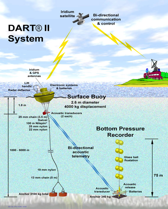
System Overview
DART® systems consist of an anchored seafloor bottom pressure recorder (BPR) and a companion moored surface buoy for real-time communications (Gonzalez et al., 1998). An acoustic link transmits data from the BPR on the seafloor to the surface buoy.
The BPR collects temperature and pressure at 15-second intervals. The pressure values are corrected for temperature effects and the pressure converted to an estimated sea-surface height (height of the ocean surface above the seafloor) by using a constant 670 mm/psia. The system has two data reporting modes, standard and event. The system operates routinely in standard mode, in which four spot values (of the 15-s data) at 15-minute intervals of the estimated sea surface height are reported at scheduled transmission times. When the internal detection software (Mofjeld) identifies an event, the system ceases standard mode reporting and begins event mode transmissions. In event mode, 15-second values are transmitted during the initial few minutes, followed by 1-minute averages. Event mode messages also contain the time of the initial occurrence of the event. The system returns to standard transmission after 4 hours of 1-minute real-time transmissions if no further events are detected.
The first generation DART® (DART I) systems had one-way communications from the BPR to the Tsunami Warning Centers (TWC) and NDBC via the western Geostationary Operational Environmental Satellite (GOES West) (Milburn et al., 1996). DART I became operational in 2003. NDBC replaced all DART I systems with the second generation DART® systems (DART II) in early 2008. DART I transmits standard mode data once an hour (four estimated sea-level height observations at 15-minute intervals). You may want to read information about the development of DART® technology.
DART II became operational in 2005 (Green, 2006). A significant capability of DART II is the two-way communications between the BPR and the TWCs/NDBC using the Iridium commercial satellite communications system (Meinig et al., 2005). The two-way communications allow the TWCs to set stations in event mode in anticipation of possible tsunamis or retrieve the high-resolution (15-s intervals) data in one-hour blocks for detailed analysis. DART II systems transmit standard mode data, containing twenty-four estimated sea-level height observations at 15-minute intervals, once very six hours. The two-way communications allow for real-time troubleshooting and diagnostics of the systems. The DART® buoys have two independent and redundant communications systems. NDBC distributes the data from both transmitters under separate transmitter identifiers. NDBC receives the data from the DART II systems, formats the data into bulletins grouped by ocean basin, and then delivers them to the National Weather Service Telecommunications Gateway (NWSTG) that then distributes the data in real-time to the TWCs via NWS communications and nationally and internationally via the Global Telecommunications System.
DART® Data Archive
NOAA’s National Centers for Environmental Information (NCEI) is the long-term archive center for recovered DART® data, please go to https://www.ngdc.noaa.gov/hazard/DARTData.shtml for more information.
References
Gonzalez, F.I., H.M. Milburn, E.N. Bernard and J.C. Newman (1998):
Deep-ocean Assessment and Reporting of Tsunamis (DART®): Brief Overview and Status Report.
In Proceedings of the International Workshop on Tsunami Disaster Mitigation,
19-22 January 1998, Tokyo, Japan.
Green, D. (2006): Transitioning NOAA Moored Buoy Systems From Research to Operations. In Proceedings of OCEANS’06 MTS/IEEE Conference, 18-21 September 2006, Boston, MA, CD-ROM.
Meinig, C., S.E. Stalin, A.I. Nakamura, H.B. Milburn (2005), Real-Time Deep-Ocean Tsunami Measuring, Monitoring, and Reporting System: The NOAA DART II Description and Disclosure.
Milburn, H.B., A.I. Nakamura, and F.I. Gonzalez (1996): Real-time tsunami reporting from the deep ocean. Proceedings of the Oceans 96 MTS/IEEE Conference, 23-26 September 1996, Fort Lauderdale, FL, 390-394.
Mofjeld, H.O., Tsunami Detection Algorithm