



About Us

The National Data Buoy Center (NDBC) maintains the world's largest real-time marine observation network dedicated to maritime safety and environmental observations for now and the future.
NDBC's network includes moored-ocean buoys, fixed coastal stations, and mobile observing platforms that observe, report, and disseminate atmospheric, oceanographic, meteorological, and tsunami measurements.
The observations gathered by NDBC support operational and research programs at the National Oceanic and Atmospheric Administration (NOAA) and other organizations, as well as the understanding and predictions of patterns in weather, oceans, and coasts.
In addition to the data from our network of approximately 240 stations, NDBC obtains and distributes observations from partner organizations across the world.
Our Vision
A sustainable and resilient marine observation and monitoring infrastructure which enhances healthy ecosystems, communities, and economies in the face of change.
Our Mission
Collecting and disseminating in-situ, real-time, quality-controlled observations in the marine environment to ensure the Nation's maritime safety, and to understand and predict the atmosphere, ocean, waves, ice, and climate.
Our Observing Platforms
Weather & CMAN Stations


Via over 100 moored buoys and over 40 land-based Coastal-Marine Automated Network (C-MAN) stations, data is collected for use in operational forecasting, warnings, and numerical models.
- Weather Buoys measure and transmit: barometric pressure; wind direction, speed and gust; air and sea temperature; relative humidity; and the wave energy spectra from which significant wave height, dominant wave period, average wave period, and direction of wave propagation are derived
- C-MAN stations are installed on lighthouses, at capes and beaches, on near-shore islands, and on offshore platforms
- C-MAN station data typically include: barometric pressure; wind direction, speed and gust; air temperature; and relative humidity
- Weather Buoys currently operate on our SCOOP payload, which includes a single-tube housing. The development of this system eliminated 800 lbs of hardware and made these stations safer for our team to service.
Tropical Atmosphere Ocean Array

The Tropical Atmosphere Ocean Array (TAO) is designed for the study of year-to-year variations related to El Nino and the Southern Oscillation (ENSO). Located in the equatorial Pacific Ocean, the array consists of 52 moored buoys extending from 9° N to 8° S Latitude and 95° W to 165° E Longitude.
The buoys collect real-time air temperature, relative humidity, wind speed and direction, ocean temperature, and pressure. Some buoys also collect barometric pressure, longwave radiation, shortwave radiation, rainfall amounts, and ocean currents.
Visit the TAO website.
DART® Buoys

Deep-ocean Assessment and Reporting of Tsunami (DART®) systems are located in regions with a history of generating destructive tsunamis throughout the Pacific and Atlantic Oceans, commonly referred to as the "Ring of Fire."
These 39 systems ensure early detection of tsunamis and acquire data critical to real-time forecasts. Each system consists of an anchored seafloor Bottom Pressure Recorder (BPR) and a companion moored surface buoy for real-time communication, utilizing acoustic transmissions.
Read more about the DART® Program.
VOS & More

On any given day, volunteer crew members on nearly 1,000 ships around the world observe the weather at their location, encode each observation in a standard format, and their info is processed by NDBC.
Learn more about the VOS Program.
NDBC also has partnerships with private companies who operate uncrewed systems and collaborate to include observations from these systems in place of or alongside NDBC observing platforms.
What is Mission Season?
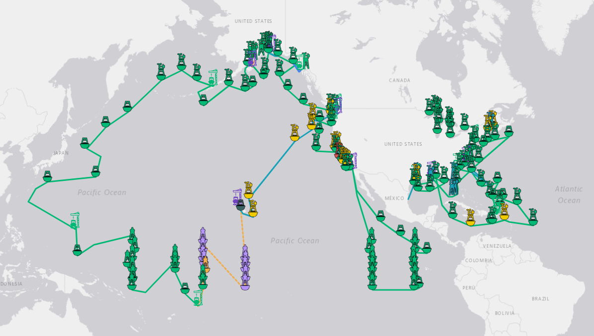
With efficiency and economic use of resources being a top priority, our team works hard to plan a service season nearly a year ahead of schedule that will allow us to touch the greatest number of NDBC stations in a given fiscal year. Usually, this involves 2 concurrent missions that begin in the spring and continue through the fall. Utilizing one vessel in the Pacific and one in the Atlantic, our team coordinates a route and sends out NDBC technicians to service stations across our network, with priority generally being given to stations that have seen degradation of availability or were not serviced in the prior year.
With stations ranging from the Equatorial Pacific near Japan to the Bering Sea to the North Atlantic seas off the Maine coast, this approach has proven to be the most reliable way to ensure our network is regularly maintained by our team stationed in coastal Mississippi. We also benefit from a terrific partnership with the United States Coast Guard who assist in many ways, including help with servicing some of our more inaccessible C-MAN stations, wintering our Great Lakes buoys, and recovery and deployment of other key stations near U.S. coastlines.
Review our Maintenance Schedule.
NDBC Leadership

Director

Marine Readiness
Division Chief

Observational Systems
Division Chief

Marine Mission Services
Division Chief
 NDBC on Facebook
 NOAA on LinkedIn
 NDBC on X