Site Search
NDBC All NOAA
View the latest observations near Atlantic Tropical Storm Arlene.
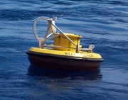
Owned and maintained by National Data Buoy Center 2.6-meter discus buoy DART II payload 50.983 N 163.943 W (50°58'57" N 163°56'35" W) Water depth: 4781 m Watch circle radius: 3532 yards
Important Notice to Mariners
Meteorological Observations from Nearby Stations and Ships
DART® Program Description
U.S. Tsunami Warning Centers
Refresh page every 10 minutes:
Data Access
Water Column Heights:05/29/2023 00:00:00 to 06/02/2023 23:59:59
The data are recorded in pounds per square inch absolute (PSIA), but are displayed in meters of water after applying a constant 670.0 mm of water/PSIA conversion factor.
T = Measurement Type; where 1 = 15-minute measurement; 2 = 1-minute measurement; 3 = 15-second measurement
Description of Measurements
Links which are specific to this station are listed below:
Real Time Data in tabular form for the last forty-five days.
Historical Data & Climatic Summaries for quality controlled data for prior months and years.
The weekly maintenance report also provides valuable station information.
Note that the payload types and the station locations occasionally change.