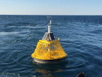
Station 46078 (LLNR 1187) - ALBATROSS BANK - 104NM South of Kodiak Is., AK
No Recent Reports
Links which are specific to this station are listed below:
Data for last 24 hours: No data available.
Data for last 5 days: No data available.
Data for last 45 days:These real time data have undergone gross error checking only. Please use with discretion.
- Real time standard meteorological data and their description.
- Real time spectral wave data and their description.
- Real time raw spectral wave data and their description.
- Real time raw spectral wave (alpha1) data and their description.
- Real time raw spectral wave (alpha2) data and their description.
- Real time raw spectral wave (r1) data and their description.
- Real time raw spectral wave (r2) data and their description.
- Real time supplemental measurements data and their description.
- Real time derived measurements data and their description.
- Quality controlled data for 2025 (data descriptions)
- Standard meteorological data: Jan Feb Mar Apr May Jun Jul Aug Sep Oct Nov Dec
- Spectral wave density data: Jan Feb Mar Apr May Jun Jul Aug Sep Oct Nov Dec
- Spectral wave (alpha1) direction data: Jan Feb Mar Apr May Jun Jul Aug Sep Oct Nov Dec
- Spectral wave (alpha2) direction data: Jan Feb Mar Apr May Jun Jul Aug Sep Oct Nov Dec
- Spectral wave (r1) direction data: Jan Feb Mar Apr May Jun Jul Aug Sep Oct Nov Dec
- Spectral wave (r2) direction data: Jan Feb Mar Apr May Jun Jul Aug Sep Oct Nov Dec
- Supplemental Measurements data: Jan Feb Mar Apr May Jun Jul Aug Sep Oct Nov Dec
- Historical data (data descriptions)
- Standard meteorological data: 2004 2005 2006 2007 2008 2009 2010 2011 2012 2013 2014 2015 2016 2017 2018 2019 2020 2021 2022 2023 2024
- Continuous winds data: 2009 2010 2011 2012 2013 2014 2015 2016 2018 2019 2020 2021
- Spectral wave density data: 2004 2005 2006 2007 2008 2009 2009b 2010 2011 2012 2013 2014 2015 2016 2017 2018 2019 2020 2021 2022 2023 2024
- Spectral wave (alpha1) direction data: 2013 2014 2015 2016 2017 2018 2019 2020 2021 2022 2023 2024
- Spectral wave (alpha2) direction data: 2013 2014 2015 2016 2017 2018 2019 2020 2021 2022 2023 2024
- Spectral wave (r1) direction data: 2013 2014 2015 2016 2017 2018 2019 2020 2021 2022 2023 2024
- Spectral wave (r2) direction data: 2013 2014 2015 2016 2017 2018 2019 2020 2021 2022 2023 2024
- Solar radiation data: 2005 2006
- Supplemental measurements data: 2010 2011 2012 2013 2014 2015 2016 2018 2019 2020 2021 2022 2023 2024
- Search historical meteorological data for observations that meet your threshold conditions
- Climatic summary table (TXT) and plots of (description of tables and plots)
Some data files have been compressed with the GNU gzip program.
The weekly status report and the weekly maintenance report also provide valuable station information.
Note that the payload types and the station locations occasionally change.


