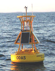
Station 44034 - Buoy I01 - Eastern Maine Shelf 
|
Click on the graph icon in the table below to see a time series plot of the last five days of that observation. | |
| SSW ( 210 deg true ) | |
| 3.9 kts | |
| 5.8 kts | |
| 2.3 ft | |
| 8 sec | |
| 29.99 in | |
| 58.6 °F | |
| 1.6 nmi | |
| 5.8 kts | |
| 5.8 kts | |
Disclaimer: Ocean current directions are reported to the nearest 10 degrees and speeds are measured to the nearest whole centimeter per second.
Ocean Current Data for 44034
| 9:04 pm EDT | 8:04 pm EDT | 7:04 pm EDT | ||||
|---|---|---|---|---|---|---|
| Depth ft | Dir ° | Speed kts |
Dir ° | Speed kts |
Dir ° | Speed kts |
| 7 | 220 | 0.60 | 210 | 0.87 | 210 | 0.95 |
| 33 | 230 | 0.80 | 210 | 0.76 | 210 | 0.78 |
| 46 | 220 | 0.45 | 220 | 0.78 | 210 | 0.85 |
| 59 | 230 | 0.41 | 220 | 0.72 | 210 | 0.84 |
| 72 | 220 | 0.41 | 220 | 0.74 | 210 | 0.82 |
| 85 | 200 | 0.43 | 220 | 0.70 | 210 | 0.80 |
| 98 | 200 | 0.41 | 220 | 0.60 | 210 | 0.78 |
| 112 | 200 | 0.39 | 220 | 0.54 | 210 | 0.76 |
| 125 | 200 | 0.35 | 210 | 0.58 | 210 | 0.74 |
| 138 | 210 | 0.35 | 210 | 0.64 | 210 | 0.70 |
| 151 | 210 | 0.37 | 210 | 0.64 | 210 | 0.64 |
| 164 | 210 | 0.39 | 210 | 0.52 | 210 | 0.56 |
| 177 | 210 | 0.39 | 210 | 0.35 | 210 | 0.51 |
| 190 | 210 | 0.37 | 210 | 0.25 | 220 | 0.41 |
| 203 | 220 | 0.27 | 220 | 0.19 | 230 | 0.25 |
| 217 | 210 | 0.12 | 210 | 0.19 | 210 | 0.25 |
| 230 | 130 | 0.08 | 200 | 0.10 | 210 | 0.35 |
| 243 | 100 | 0.16 | 170 | 0.12 | 200 | 0.35 |
| 256 | 90 | 0.27 | 150 | 0.14 | 200 | 0.25 |
| 269 | 80 | 0.35 | 150 | 0.10 | 190 | 0.21 |
| 282 | 80 | 0.37 | 120 | 0.10 | 170 | 0.17 |
| 295 | 80 | 0.41 | 80 | 0.12 | 150 | 0.19 |
Previous (up to 48) reports of ocean current data for 44034
Ocean Current Stick Plots are available in metric units only:
All Instruments -  1-day plot
  3-day plot
  5-day plot
Links which are specific to this station are listed below:
Real Time Data in tabular form for the last forty-five days.
Historical Data & Climatic Summaries for quality controlled data for prior months and years.


