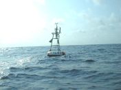
Station 15006 - Valse
Map Type:
Select Basemap
Oceans
Satellite
Streets
Topographic
03 29 1200 WNW 4.9 6.8 - - - - - - 77.5 83.1 - - - -
03 29 1100 W 10.5 13.4 - - - - - - 76.5 82.9 - - - -
03 29 1000 WSW 15.9 19.0 - - - - - - 75.2 82.9 - - - -
03 29 0900 SE 5.1 6.8 - - - - - - 79.2 83.1 - - - -
03 29 0800 SSE 10.7 13.8 - - - - - - 77.9 83.1 - - - -
03 29 0700 ESE 4.1 5.6 - - - - - - 80.6 83.1 - - - -
03 29 0600 ESE 5.8 8.4 - - - - - - 80.8 83.1 - - - -
03 29 0500 ESE 5.6 7.2 - - - - - - 80.6 82.9 - - - -
03 29 0400 SE 4.5 6.0 - - - - - - 80.1 83.1 - - - -
03 29 0300 ESE 4.3 6.6 - - - - - - 79.9 83.1 - - - -
03 29 0200 SE 5.4 8.0 - - - - - - 79.7 82.9 - - - -
03 29 0100 ESE 8.0 10.5 - - - - - - 79.0 82.9 - - - -
03 29 0000 ESE 8.2 10.1 - - - - - - 79.2 83.1 - - - -
03 28 2300 SE 10.5 13.0 - - - - - - 78.4 83.1 - - - -
03 28 2200 SE 11.5 15.0 - - - - - - 78.4 83.1 - - - -
03 28 2100 SE 12.0 14.2 - - - - - - 77.5 82.9 - - - -
03 28 2000 SE 13.0 15.0 - - - - - - 77.0 83.1 - - - -
03 28 1900 ENE 10.7 13.0 - - - - - - 79.5 83.1 - - - -
03 28 1800 SE 8.7 11.7 - - - - - - 80.2 83.1 - - - -
03 28 1700 SE 12.8 15.2 - - - - - - 79.7 83.1 - - - -
03 28 1600 SE 12.0 14.2 - - - - - - 80.4 83.1 - - - -
Description of Measurements
Links which are specific to this station are listed below:
Real Time Data in tabular form for the last forty-five days.
Historical Data & Climatic Summaries for quality controlled data for the current month, previous months, and previous years.