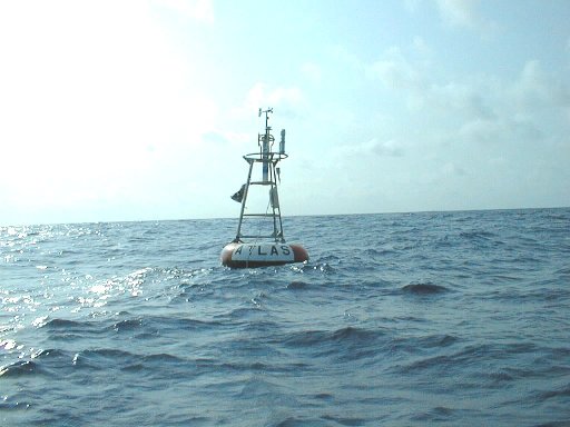
Station 13001 - NE Extension ![Image indicating link to RSS feed of recent meteorological observations for station 13001](/images/feed-icon-14x14.png)
Previous observations
TIME (GMT) |
![5-day plot - Wind Direction 5-day plot - Wind Direction](/images/graph04.gif) WDIR |
![5-day plot - Wind Speed 5-day plot - Wind Speed](/images/graph04.gif) WSPD kts |
![5-day plot - Wind Gust 5-day plot - Wind Gust](/images/graph04.gif) GST kts |
![5-day plot - Wave Height 5-day plot - Wave Height](/images/graph04.gif) WVHT ft |
![5-day plot - Dominant Wave Period 5-day plot - Dominant Wave Period](/images/graph04.gif) DPD sec |
![5-day plot - Average Wave Period 5-day plot - Average Wave Period](/images/graph04.gif) APD sec |
![5-day plot - Mean Wave Direction 5-day plot - Mean Wave Direction](/images/graph04.gif) MWD |
![5-day plot - Atmospheric Pressure 5-day plot - Atmospheric Pressure](/images/graph04.gif) PRES in |
![5-day plot - Pressure Tendency 5-day plot - Pressure Tendency](/images/graph04.gif) PTDY in |
![5-day plot - Air Temperature 5-day plot - Air Temperature](/images/graph04.gif) ATMP °F |
![5-day plot - Water Temperature 5-day plot - Water Temperature](/images/graph04.gif) WTMP °F |
![5-day plot - Dew Point 5-day plot - Dew Point](/images/graph04.gif) DEWP °F |
![5-day plot - Salinity 5-day plot - Salinity](/images/graph04.gif) SAL psu |
![5-day plot - Visibility 5-day plot - Visibility](/images/graph04.gif) VIS nmi |
![5-day plot - Tide (above MLLW) 5-day plot - Tide (above MLLW)](/images/graph04.gif) TIDE ft |
2024-07-27 0400 | WSW | 11.1 | 13.2 | - | - | - | - | 29.94 | - | 80.2 | 81.7 | - | - | - | - |
2024-07-27 0300 | WSW | 13.4 | 15.3 | - | - | - | - | 29.94 | - | 80.8 | 81.7 | - | - | - | - |
2024-07-27 0200 | WSW | 11.5 | 14.6 | - | - | - | - | 29.95 | - | 80.6 | 81.7 | - | - | - | - |
2024-07-27 0100 | SW | 10.7 | 13.0 | - | - | - | - | 29.97 | - | 80.8 | 81.7 | - | - | - | - |
2024-07-27 0000 | WSW | 10.3 | 11.8 | - | - | - | - | 29.98 | - | 80.6 | 81.5 | - | - | - | - |
2024-07-26 2300 | WSW | 10.9 | 13.0 | - | - | - | - | 29.96 | - | 80.6 | 81.7 | - | - | - | - |
2024-07-26 2200 | SW | 9.9 | 12.6 | - | - | - | - | 29.96 | - | 79.7 | 81.7 | - | - | - | - |
2024-07-26 2100 | WSW | 9.5 | 11.1 | - | - | - | - | 29.94 | - | 80.4 | 81.7 | - | - | - | - |
2024-07-26 2000 | WSW | 10.7 | 12.8 | - | - | - | - | 29.93 | - | 80.1 | 81.7 | - | - | - | - |
2024-07-26 1900 | W | 10.5 | 12.0 | - | - | - | - | 29.92 | - | 79.7 | 81.7 | - | - | - | - |
2024-07-26 1800 | WSW | 10.9 | 13.0 | - | - | - | - | 29.91 | - | 80.1 | 81.7 | - | - | - | - |
2024-07-26 1700 | SW | 10.7 | 12.8 | - | - | - | - | 29.91 | - | 79.5 | 81.7 | - | - | - | - |
2024-07-26 1600 | SSW | 8.0 | 9.7 | - | - | - | - | 29.93 | - | 77.5 | 81.7 | - | - | - | - |
2024-07-26 1500 | WSW | 8.2 | 10.3 | - | - | - | - | 29.94 | - | 78.4 | 81.7 | - | - | - | - |
2024-07-26 1400 | WSW | 10.9 | 13.2 | - | - | - | - | 29.96 | - | 77.7 | 81.7 | - | - | - | - |
2024-07-26 1300 | SW | 8.9 | 10.7 | - | - | - | - | 29.97 | - | 79.0 | 81.7 | - | - | - | - |
2024-07-26 1200 | SW | 9.3 | 11.8 | - | - | - | - | 29.98 | - | 78.6 | 81.5 | - | - | - | - |
2024-07-26 1100 | SW | 10.5 | 12.8 | - | - | - | - | 29.98 | - | 79.2 | 81.5 | - | - | - | - |
2024-07-26 1000 | SW | 14.4 | 16.3 | - | - | - | - | 29.97 | - | 78.4 | 81.5 | - | - | - | - |
2024-07-26 0900 | SW | 10.5 | 12.6 | - | - | - | - | 29.96 | - | 78.6 | 81.5 | - | - | - | - |
2024-07-26 0800 | W | 13.6 | 15.7 | - | - | - | - | 29.94 | - | 78.1 | 81.5 | - | - | - | - |
2024-07-26 0700 | WSW | 13.8 | 16.3 | - | - | - | - | 29.94 | - | 77.4 | 81.7 | - | - | - | - |
2024-07-26 0600 | WSW | 9.9 | 12.6 | - | - | - | - | 29.93 | - | 79.5 | 81.7 | - | - | - | - |