How do tropical storms differ from winter storms?
Tropical and extratropical cyclones have different data traces as they pass by our stations. Tropical cyclones are hurricanes or tropical storms. Extratropical cyclones are winter storms, or typical low pressure areas.
Take a look at the following time-series plots, and see if you can figure out whether the storm is tropical or extratropical.

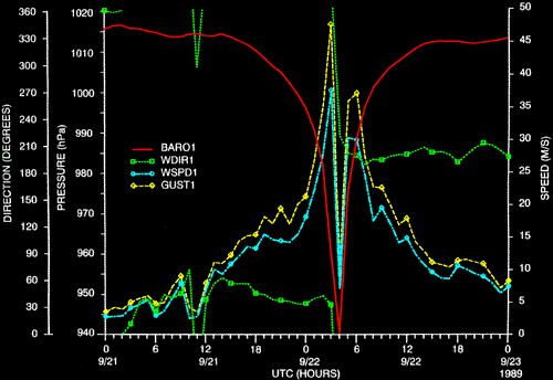
If you thought this was a tropical cyclone, you are correct. These measurements were taken by our station at Folly Beach, SC (near Charleston), during the passage of Hurricane Hugo.
Note the abrupt, large drop in pressure in a few hours that accompanied the storm; then, the almost perfectly symmetrical rise on the other side of the eye. Also, notice the 1-hour lull in winds flanked by abrupt peaks on either side that marks he eye wall. Tropical systems are often small compared with extratropical ones.
No evidence is shown for any fronts. Fronts are zones of temperature contrast accompanied by wind shifts and pressure kinks. With the exception of a few random hours, the air temperature stays between 24 to 26 degrees C. The wind directions blow constantly from the NE for 15 hours before the eye strikes. Then, they blow from SW for 18 hours after the eye passes.
Now, take a look at the following time-series plots. Is this a tropical or extratropical cyclone?

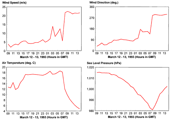
This is an extratropical or winter storm. In fact, this is a famous one -- the March 1993 Superstorm, also called The Storm of the Century that passed directly over Cape San Blas, FL. Perhaps the colder temperatures give the answer away, but other, more fundamental reasons exist.
The pressure fall was gradual and had several minor kinks. The winds did not show the double-peak pattern of a tropical system or a lull that would be associated with an eye.
The air temperatures show a big rise about 18 hours before the time of lowest pressure. The temperature fell precipitously starting at the time of lowest pressure. The wind direction shifted from NNE to E, SSE, then to NW. The wind direction shifts are related to the temperature rising and falling. Clearly, this was evidence for warm and cold frontal passages.
Actually, three frontal passages occurred. The first happened about hour 13 on March 12 when the air temperature rose from 12 to more than 17 degrees C 4 hours later. This happened well ahead of the low pressure area and was caused by a minor wind shift from the NE to the E that brought warmer air from offshore. Meteorologists call this type of warm front, a coastal front. The second frontal passage happened about hour 00 on March 13 when the wind direction started to shift from the E to the S and the temperature began a minor rise from 17 to 18 degrees C. This was the warm front associated with the low. The cold front passed between hours 07 and 08 when the wind shifted to the NW and the temperature fell quickly.
These fronts, along with differences in wind speed and direction in the atmosphere, provided the energy for extratropical low pressure areas. In contrast, the energy for tropical cyclones comes from the sea.
Now -- just when you think you understand this -- I want to show you one more set of time-series plots. Is this a tropical system or an extratropical one?

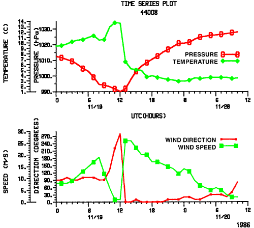
This looks a bit like both. It is from a winter storm that sports a tropical look. The winds drop to almost a dead calm when the pressure is lowest and then quickly jump to 27 m/s (52 kn). This is evidence for an eye and eye wall.
Otherwise, this looks like a winter storm because we can see fronts. A warm front passed at about hour 07 or 08 because of the kink in the pressure trace, the wind shifted from the E to S, and the 4 degrees C temperature rose. The cold front arrived between hours 12 and 13 when the wind shifted to the N and the temperature fell 9 degrees C in 1 hour.
For an interesting article on these types of storms, see "Hurricanes in Disguise" by Robert Hanson in the December 1995 issue of Weatherwise.
Return to Science Education Home


