


![]() View the latest observations near Atlantic Tropical Storm Bertha and East Pacific Hurricane Fausto.
View the latest observations near Atlantic Tropical Storm Bertha and East Pacific Hurricane Fausto.
Does water temperature differ between near-shore and offshore sites? Why or why not?

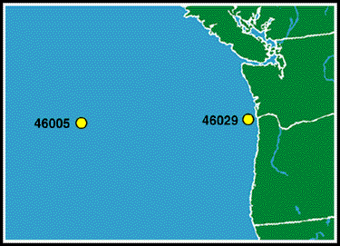
The graph shows the average monthly water temperatures from Station 46029 and Station 46005. These two stations are on the same latitude -- about 46 degrees North latitude. They are only 312 miles apart! Look at the data for September. Station 46029 has an average water temperature of 15 degrees while Station 46005 has an average water temperature of over 17 degrees. You would think that the water temperatures would be very similar to each other. But as you can see from the graph, the water temperatures for August through December are substantially cooler at Station 46029.
Okay, so we know that water temperatures from near-shore sites differ from temperatures offshore. How does this occur?