


![]() View the latest observations near Central Pacific Tropical Storm Fausto and East Pacific Hurricane Genevieve.
View the latest observations near Central Pacific Tropical Storm Fausto and East Pacific Hurricane Genevieve.
What are hurricanes? What happens during a hurricane?
Hurricanes are intense storms that originate in the Tropics. Hurricanes begin life as a small gathering of unorganized storms which gain energy from the heat of the ocean water. If certain conditions in the atmosphere are present, the gathering of individual clouds will begin to organize into a single storm. If the storm continues to feed off the heat supplied by the ocean, the organization of the cloud clusters will intensify and the winds will increase and circulate around a specific center, the eye. As a matter of fact, meteorologists place hurricanes in a category called cyclones. Cyclones are characterized by a circular wind pattern or circulation. Tornadoes, waterspouts, and dust devils are also members of this category.
Meteorologists identify the growth phase of hurricanes into three categories of development:
- Tropical Depression -- wind speeds less than 39 mph
- Tropical Storm -- wind speeds between 39 mph and 73 mph
- Hurricane -- wind speeds greater than 74 mph
The hurricanes that affect the United States are "born" in the Atlantic Ocean, the Gulf of America, or the Caribbean Sea and travel to the northwest at a speed near 15 mph. As these storms travel, the wind, rain, and storm surge destroy the shoreline, villages, and cities in their path. Storm surge is a rise of the ocean caused by the winds of the storm. The highest surge is typically to the right of the hurricane and has been known to exceed 25 feet. This is due to the combination of the strong winds and the forward movement of the hurricane. Tornadoes have also been known to originate from the severe atmospheric conditions associated with hurricanes. When hurricanes make landfall, they begin to decrease in strength because they no longer have the ocean water from which to gain energy. However, they are still dangerous and can cause much damage.
Different areas of the world have different names for what we call a "hurricane":
- Caribbean Sea, North Atlantic Ocean, Gulf of America --"hurricane"
- Haiti -- "taino"
- Indian Ocean -- "cyclone"
- Philippines - "baguio" or "baruio"
- West coast of Mexico -- "cordonazo"
- Western North Pacific Ocean and the South Pacific -- "typhoon"

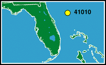
This figure shows plots of average wind speed, peak gust speed, average wind direction, and barometric pressure measured at Station 41010 during Hurricane Dorian in 2019. Wind gusts are sudden brief increases in the wind speed and usually last less than 20 seconds. When do you think the hurricane passed near this station? Take a few moments and look at the figure.
During a hurricane, the air pressure decreases. This is the most important characteristic of a hurricane. Now do you think you know when Dorian passed? On September 4, near hour 5. It is at this time that the air pressure was at a minimum. Also, the wind speeds increase when a hurricane approaches. At hour 5, the wind speed and wind gust are near their maximum values of 28 meters/second and 38 meters/second, respectively. Keep in mind that Station 41010 was not near the most dangerous and intense area of the hurricane -- the eye wall. If this station were nearer the eye wall, the wind speeds and gusts would have been much higher and the air pressure would have been much lower.
Another mark of a hurricane is that the wind direction (the direction from which the wind blows) changes. Recall from the previous page on sea breezes that scientists assign numbers to various wind directions. The plot shows that the wind direction increased from about 60 degrees (a wind from the east-northeast) to 130 degrees (a wind from the southeast) right before the storm passed the station. After the storm passed, the wind direction steadily increased to 200 degrees (a wind from the south-southwest).
Return to Science Education Home