


Does water temperature differ between near-shore and offshore sites? Why or why not?
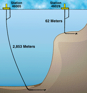
The above graph shows the water depths of the two buoy stations in question. As you can see, Station 46005 sits several hundred miles offshore in over 2800 meters of water.
There are several factors which can influence the sea surface temperature of near-shore buoys more so than off-shore buoys. These include river runoff, higher cooling and heating rates, continental air masses, near-shore ocean currents, and upwelling effects. In the case of buoys 46005 and 46029 off of the west coast of the U.S. mainland, upwelling is the dominant cause of the sea surface temperature differences.
Upwelling is the movement of cold water from deeper depths to the top of the ocean. Along the coasts of the states of Washington, Oregon, and California, the coastal winds effectively transport surface waters off-shore. Seawater must rise from the depths to replenish the water that is being pushed from the coast; these cooler, nutrient-rich waters rise from depths of 50-300 meters to the surface of the ocean. The waters just along the coast can be several degrees cooler in the summer than the waters offshore. These cool, coastal upwelled waters are very evident in the yearly sea surface temperature animation shown below.
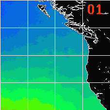
The temperatures are in degrees Celsius, and the month number is shown in the upper right hand corner of the animation. These monthly averages of sea surface temperature were calculated from data collected by a satellite orbiting hundreds of miles above the Earth's surface between the years 1987 and 1990. The cool upwelled waters are shown by the lighter colors that are adjacent to the west coast of the North American continent.
Return to Science Education Home