


What are sea breezes and why do they occur?
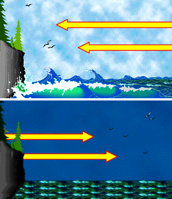
Sea breezes occur during hot, summer days because of the unequal heating rates of land and water. During the day, the land surface heats up faster than the water surface. Therefore, the air above the land is warmer than the air above the ocean. Now, recall that warmer air is lighter than cooler air. As a result, warm air rises. Therefore, the warmer air over the land surface is rising. As the warm air over the land is rising, the cooler air over the ocean is flowing over the land surface to replace the rising warm air. This is the sea breeze and can be seen at the top of the following image. The bottom of the following image illustrates the land breeze that occurs at night. Recall that the land surface cools quicker than the water surface at night. Therefore, the warmer air over the ocean is buoyant and is rising. The denser cool air over the land is flowing offshore to replenish the buoyant warm air and is called a land breeze.
Return to Science Education Home