|
|
Station List Observations Mobile Access Obs via Google Maps Classic Maps Recent Historical DART® Oil & Gas ADCP Obs Search Ship Obs Report Gliders APEX TAO DODS HF Radar OSMC Dial-A-Buoy RSS Feeds Obs Web Widget Email Access Station Status NDBC Maintenance NDBC Platforms Partner Platforms Program Info NDBC on Facebook About NDBC Met/Ocean Moored Buoy C-MAN TAO DART® VOS CSP IOOS® Program IOOS® DAC Publications NDBC DQC Handbook Hurricane Data Plots Mariners Weather Log Observing Handbook No. 1 Science Education NDBC Director FAQ Media Inquiries Contact Us Visitor Information Links |
See recent photos from NDBC weather buoy 42039 in the Gulf of Mexico. See recent photos from the following TAO stations: 2N 95W, 0 95W, 2S 95W, 8N 110W, 5N 110W, 2N 110W, 0 110W NDBC Science Education PagesHow are ocean waves described?![]() 
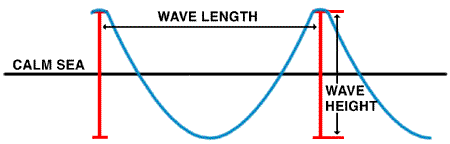
Scientists use two measures to describe ocean waves: height and length. As is shown on the figure, wave height is defined as the height of the wave from the wave top, called the wave crest to the bottom of the wave, called the wave trough. The wave length is defined as the horizontal distance between two successive crests or troughs. During storms, the wave heights increase while the wave lengths decrease. Wave heights during storms may exceed 10 meters (33 feet)!! These waves are extremely dangerous to any boater or surfer out on the water. So, stay out of the water during storms. The wave length during storms tend to decrease; some may be as small as 15 meters (50 feet). What do you think happens to wave height during a hurricane? |