Skip Navigation Links weather.gov 
NOAA logo-Select to go to the NOAA homepage NDBC Title GraphicClick to go to NDBC home page   Select to go to the NWS homepage
Home News Organization


    Station List

 Observations
    Mobile Access
    Observations via
      Google Maps

    Classic Maps
         Recent
         Historical
         DART®
         MMS ADCP
    Obs Search
    Ship Obs Report
    APEX
    TAO
    DODS
    HF Radar
    OSMC
    Dial-A-Buoy
    RSS Feeds Image indicating link to RSS feed access page
    Email Access

 Station Status
    NDBC Maintenance
    NDBC Platforms
    Partner Platforms

 Program Info
    About NDBC
     Met/Ocean
          Moored Buoy
          C-MAN
    TAO
    DART®
    VOS
    CSP
    IOOS® DAC

 Publications
    NDBC DQC Handbook
    Hurricane Data Plots
    Mariners Weather
      Log

    Observing
      Handbook No. 1


 Science Education

 FAQ
 Contact Us
 Links
 
USA.gov is the U.S. government's official web portal to all federal, state and local government web resources and services.

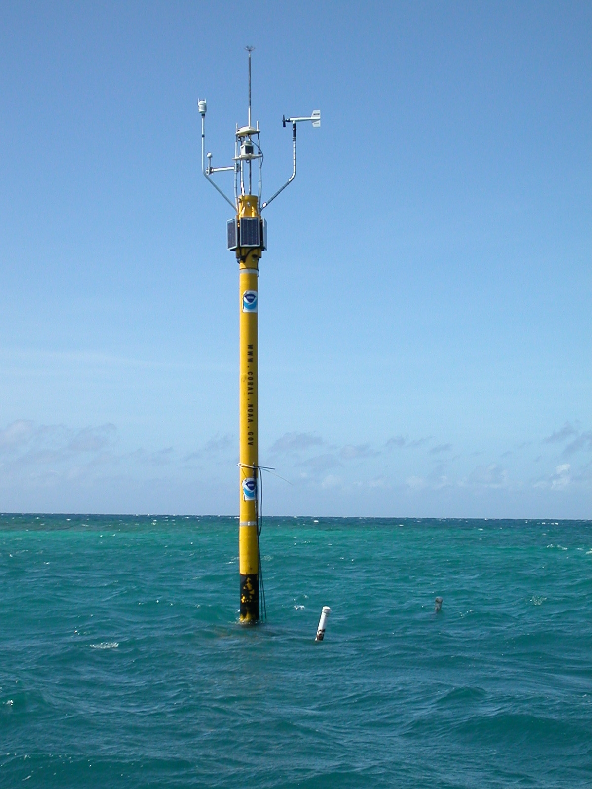
Station LPRP4 - Media Luna, La Parguera, PR Image indicating link to RSS feed of recent meteorological observations for station LPRP4

Station LPRP4

Owned and maintained by Integrated Coral Observing Network (ICON)
Fixed Structure Weather Station
17.939 N 67.052 W (17°56'19" N 67°3'7" W)

Site elevation: sea level
Air temp height: 6.5 m above site elevation
Anemometer height: 6.5 m above site elevation
Barometer elevation: 6.5 m above mean sea level
Sea temp depth: -1.1 m below site elevation
Water depth: 6.5 m

Search And Rescue (SAR) Data

Meteorological Observations from Nearby Stations and Ships Image indicating link to RSS feed of recent meteorological observations near station LPRP4

Latest Satellite Wind Map for this Area


Conditions at LPRP4 as of
0000 GMT on 11/25/2009:

Note: This report is more than two hours old
Unit of Measure:    Time Zone:   

Click on the graph icon in the table below to see a time series plot of the last five days of that observation.

5-day plot - Wind DirectionWind Direction (WDIR):NNE ( 20 deg true )
5-day plot - Wind SpeedWind Speed (WSPD):3.6 m/s
5-day plot - Wind GustWind Gust (GST):7.7 m/s
5-day plot - Atmospheric PressureAtmospheric Pressure (PRES):1012.4 mb
5-day plot - Air TemperatureAir Temperature (ATMP): 27.9 °C
5-day plot - Water TemperatureWater Temperature (WTMP): 29.3 °C
5-day plot - SalinitySalinity (SAL): 34.48 psu
5-day plot - Dew PointDew Point (DEWP): 23.5 °C
5-day plot - Heat IndexHeat Index (HEAT): 31.4 °C
5-day plot - Wind Speed, Wind Gust and Atmospheric PressureCombined plot of Wind Speed, Gust, and Air Pressure
Supplemental Measurements

Note: This report is more than two hours old
Lowest 1-minute Pressure
Time (GMT) Pressure
0000 1012.1 mb
Highest 1-minute Wind Speed
Time (GMT) 5-day plot - 1-Minute Wind Speed WSPD 5-day plot - 1-Minute Wind Direction WDIR
2329 7.0 m/s ESE ( 104 deg true )
Previous observations
5-day plot - Wind Direction5-day plot - Wind Speed5-day plot - Wind Gust5-day plot - Wave Height5-day plot - Dominant Wave Period5-day plot - Average Period5-day plot - Mean Wave Direction5-day plot - Atmospheric Pressure5-day plot - Pressure Tendency5-day plot - Air Temperature5-day plot - Water Temperature5-day plot - Dew Point5-day plot - Salinity5-day plot - Visibility5-day plot - Tide (above MLLW)
MM DD TIME
(GMT)
   WDIR WSPD
m/s
GST
m/s
WVHT
m
DPD
sec
APD
sec
MWD PRES
mb
PTDY
mb
ATMP
°C
WTMP
°C
DEWP
°C
SAL
psu
VIS
km
TIDE
m
11242354   NNE 3.6---------- 34.48--
11242348   NNE 3.6---------- 34.48--
11242342    NE 3.1-------------
11242336   ENE 5.1-------------
11242330    E 5.7-------------
11242324    E 6.2-------------
11242318    E 5.7-------------
11242312    E 6.2---------- 34.47--
11242306    E 6.7---------- 34.47--
11242300    E 5.7 7.7----1012.1 +1.2 28.7 29.4 23.1 34.47--
11242254    E 6.2---------- 34.47--
11242248    E 5.7---------- 34.47--
11242242    E 5.7-------------
11242236    E 6.2-------------
11242230    E 6.2-------------
11242224   ESE 4.6-------------
11242218    E 5.1-------------
11242212    E 5.7---------- 34.48--
11242206    E 6.2---------- 34.48--
11242200    E 5.7 9.3----1011.8- 28.8 29.4 22.9 34.48--
11242154    E 6.2---------- 34.48--
11242148   ESE 6.2---------- 34.48--
11242142   ESE 6.7-------------
11242136   ESE 6.2-------------
11242130    E 6.7-------------
11242124    E 7.2-------------
11242118   ESE 7.2-------------
11242112   ESE 8.2-------------
11242106   ESE 7.7-------------
11242000   ESE 6.2 8.8----1010.9 -1.2 28.7 29.4 22.5 34.47--
11241954   ESE 6.2---------- 34.47--
11241948   ESE 6.7---------- 34.47--
11241942   ESE 6.7-------------
11241936   ESE 6.7-------------
11241930   ESE 6.7-------------
11241924   ESE 6.2-------------
11241918   ESE 6.2-------------
11241912   ESE 6.7---------- 34.47--
11241906   ESE 6.7---------- 34.47--
11241900   ESE 6.2 9.8----1010.9 -1.9 28.6 29.5 22.6 34.47--
11241854   ESE 6.7---------- 34.47--
11241848   ESE 6.2---------- 34.47--
11241842   ESE 6.7-------------
11241836   ESE 7.2-------------
11241830   ESE 7.7-------------
11241824   ESE 7.7-------------
11241818   ESE 7.7-------------
11241812   ESE 8.2---------- 34.47--
11241806   ESE 8.2---------- 34.47--
11241800   ESE 7.7 8.8----1011.2 -2.6 28.6 29.5 22.7 34.47--
11241754   ESE 7.2---------- 34.47--
11241748   ESE 6.7---------- 34.47--
11241742   ESE 7.7-------------
11241736   ESE 7.2-------------
11241730   ESE 7.2-------------
11241724   ESE 7.2-------------
11241718   ESE 6.7-------------
11241712   ESE 7.2---------- 34.48--
11241706   ESE 7.2---------- 34.48--
11241700   ESE 7.2 8.8----1012.1 -2.2 28.7 29.5 22.0 34.48--
11241654   ESE 6.7---------- 34.48--
11241648   ESE 6.7---------- 34.48--
11241642   ESE 6.2-------------
11241636   ESE 6.7-------------
11241630   ESE 7.2-------------
11241624   ESE 6.7-------------
11241618   ESE 7.2-------------
11241612   ESE 7.2---------- 34.48--
11241606   ESE 7.2---------- 34.48--
11241600   ESE 7.2 8.8----1012.8 -1.5 28.4 29.4 22.0 34.48--
11241554   ESE 7.2---------- 34.48--
11241548   ESE 6.7---------- 34.48--
11241542   ESE 6.7-------------
11241536   ESE 6.7-------------
11241530   ESE 6.7-------------
11241524   ESE 7.2-------------
11241518   ESE 7.7-------------
11241512   ESE 7.2---------- 34.47--
11241506   ESE 7.2---------- 34.47--
11241500   ESE 7.7 8.8----1013.8 +0.0 28.3 29.4 21.4 34.47--
11241454   ESE 7.2---------- 34.47--
11241448   ESE 7.7---------- 34.47--
11241442   ESE 7.2-------------
11241436   ESE 7.7-------------
11241430    E 5.1-------------
11241424    NE 2.6-------------
11241418   NNE 2.6-------------
11241412    NE 3.6---------- 34.47--
11241406    E 5.1---------- 34.47--
11241400   ENE 4.6 8.2----1014.3 +0.8 28.1 29.3 21.7 34.47--
11241354   ENE 2.6---------- 34.47--
11241348   ENE 2.1---------- 34.47--
11241342   ENE 2.6-------------
11241336    E 3.1-------------
11241330   ENE 2.1-------------
11241324    E 1.0-------------
11241318    E 1.5-------------
11241312   ENE 1.5---------- 34.47--
11241306   ENE 1.5---------- 34.47--
11241300    E 1.0 2.1----1014.3 +1.4 27.2 29.3 20.7 34.47--
11241254   ENE 1.0---------- 34.47--
11241248   ENE 1.5---------- 34.47--
11241242   ENE 1.0-------------
11241236    E 1.0-------------
11241230   ENE 1.0-------------
11241224   ENE 1.0-------------
11241218    E 1.0-------------
11241212    E 1.0---------- 34.47--
11241206   ENE 1.0---------- 34.47--
11241200   ENE 0.5 2.6----1013.8 +1.2 27.0 29.2 20.1 34.47--
11241154    NE 1.0---------- 34.47--
11241148   NNE 1.0---------- 34.47--
11241142   NNE 1.5-------------
11241136    NE 1.0-------------
11241130   ENE 1.0-------------
11241124    NE 1.0-------------
11241118    NE 1.5-------------
11241112    N 1.0---------- 34.46--
11241106    N 1.5---------- 34.46--
11241100    N 1.5 2.6----1013.5 +1.0 26.4 29.2 20.4 34.46--
11241054   NNE 1.5---------- 34.46--
11241048    N 1.0---------- 34.46--
11241042    NW 1.0-------------
11241036    NW 0.5-------------
11241030   WNW 0.5-------------
11241024   - 0.0-------------
11241018   - 0.0-------------
11241012   WNW 0.5---------- 34.46--
11241006   - 0.0---------- 34.46--
11241000   - 0.0 2.6----1012.9 +0.4 26.0 29.2 20.9 34.46--
11240954   - 0.0---------- 34.46--
11240948   WNW 0.5---------- 34.46--
11240942   - 0.0-------------
11240936    W 0.5-------------
11240930   WNW 0.5-------------
11240924   - 0.0-------------
11240918    NW 1.0-------------
11240912   NNW 1.5---------- 34.46--
11240906   NNW 2.1---------- 34.46--
11240900   NNW 1.5 2.6----1012.6 +0.0 25.9 29.2 21.6 34.46--
11240854   NNW 1.0---------- 34.46--
11240848    N 1.0---------- 34.46--
11240842    N 1.0-------------
11240836   - 0.0-------------
11240830    W 1.0-------------
11240824   WNW 1.0-------------
11240818    NW 1.0-------------
11240812    N 1.5---------- 34.46--
11240806   NNE 2.1---------- 34.46--
11240800   NNW 0.5 3.1----1012.5 -0.9 25.7 29.2 20.3 34.46--
11240754   - 0.0---------- 34.46--
11240748   - 0.0---------- 34.46--
11240742   NNE 2.1-------------
11240736   NNW 0.5-------------
11240730    N 1.0-------------
11240724   NNW 1.0-------------
11240718   - 0.0-------------
11240712   NNW 1.0---------- 34.46--
11240706   NNW 1.5---------- 34.46--
11240700   NNW 1.5 3.6----1012.5 -1.3 25.2 29.2 20.0 34.46--
11240654    NW 0.5---------- 34.46--
11240648    N 1.5---------- 34.46--
11240642    N 1.5-------------
11240636   NNE 2.6-------------
11240630   NNE 2.6-------------
11240624   NNE 2.1-------------
11240618    NW 0.5-------------
11240612    NW 0.5---------- 34.47--
11240606    NW 0.5---------- 34.47--
11240600   - 0.0 1.5----1012.7 -1.4 25.7 29.2 21.9 34.47--
11240554   - 0.0---------- 34.47--
11240548   - 0.0---------- 34.47--
11240542   - 0.0-------------
11240536   - 0.0-------------
11240530   NNW 0.5-------------
11240524   NNW 0.5-------------
11240518   - 0.0-------------
11240512   - 0.0---------- 34.47--
11240506   WNW 0.5---------- 34.47--
11240500    W 1.0 1.5----1013.4 -0.7 26.2 29.2 22.5 34.47--
11240454    W 0.5---------- 34.47--
11240448   WSW 0.5---------- 34.47--
11240442   - 0.0-------------
11240436   - 0.0-------------
11240430   - 0.0-------------
11240424   - 0.0-------------
11240418   - 0.0-------------
11240412   - 0.0---------- 34.47--
11240406   - 0.0---------- 34.47--
11240400   - 0.0 1.5----1013.8 -0.3 26.4 29.3 22.9 34.47--
11240354   - 0.0---------- 34.47--
11240348   - 0.0---------- 34.47--
11240342   - 0.0-------------
11240336   - 0.0-------------
11240330   - 0.0-------------
11240324   WNW 0.5-------------
11240318    W 0.5-------------
11240312   WNW 0.5---------- 34.47--
11240306   - 0.0---------- 34.47--
11240300   - 0.0 2.1----1014.1 +0.0 26.5 29.3 23.7 34.47--
11240254   - 0.0---------- 34.47--
11240248   - 0.0---------- 34.47--
11240242   - 0.0-------------
11240236   - 0.0-------------
11240230   - 0.0-------------
11240224   NNW 1.0-------------
11240218    N 1.5-------------
11240212    N 1.0---------- 34.47--
11240206    N 1.0---------- 34.47--
11240200   NNW 1.0 2.6----1014.1 +0.4 26.3 29.3 23.6 34.47--
11240154   NNW 0.5---------- 34.47--

Ocean Conditions at LPRP4 as of
0000 GMT on 11/25/2009:

Note: This report is more than two hours old

These oceanographic data are displayed in rounded times.

Unit of Measure:    Time Zone:   

Click on the graph icon in the table below to see a time series plot of the last five days of that observation.

 Depth (DEPTH): 1.4 m
5-day plot - Ocean TemperatureOcean Temperature (OTMP):29.33 °C
5-day plot - SalinitySalinity (SAL):34.48 psu
Previous observations
5-day plot - Ocean Temperature5-day plot - Conductivity5-day plot - Salinity5-day plot - Oxygen Concentration (O2PCT)5-day plot - Oxygen Concentration (O2PPM)5-day plot - Chlorophyll5-day plot - Turbidity5-day plot - pH5-day plot - Eh
MM   DD    TIME
(GMT)
DEPTH
m
       OTMP
°C
   COND
mS/cm
  SAL
psu
  O2%
%
   O2PPM
ppm
CLCON
ug/l
TURB
FTU
PH EH
mv
11242300 1.429.38-34.47------
11242200 1.429.43-34.48------
11242000 1.429.43-34.47------
11241900 1.429.47-34.47------
11241800 1.429.50-34.47------
11241700 1.429.49-34.48------
11241600 1.429.43-34.48------
11241500 1.429.39-34.47------
11241400 1.429.32-34.47------
11241300 1.429.27-34.47------
11241200 1.329.23-34.47------
11241100 1.329.23-34.46------
11241000 1.329.22-34.46------
11240900 1.329.23-34.46------
11240800 1.229.20-34.46------
11240700 1.229.20-34.46------
11240600 1.229.20-34.47------
11240500 1.329.21-34.47------
11240400 1.329.25-34.47------
11240300 1.329.26-34.47------
11240200 1.429.32-34.47------

Description of Measurements

Links which are specific to this station are listed below:

Real Time Data in tabular form for the last forty-five days.

Historical Data & Climatic Summaries for quality controlled data for the current month, previous months, and previous years.


U.S. Dept. of Commerce
National Oceanic and Atmospheric Administration
National Weather Service
National Data Buoy Center
    1007 Balch Blvd.
    Stennis Space Center, MS 39529
Contact Us
Page last modified: October 27, 2009
Disclaimer
Information Quality
Credits
Glossary
Privacy Policy
Freedom of Information
About Us
Career Opportunities