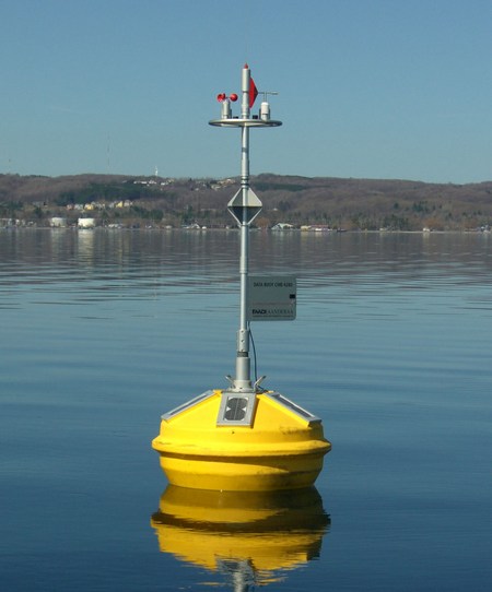
Skip Navigation Links weather.gov 
NOAA logo-Select to go to the NOAA homepage NDBC Title GraphicClick to go to NDBC home page   Select to go to the NWS homepage
Home News Organization


    Station List

 Observations
    Mobile Access
    Observations via
      Google Maps

    Classic Maps
         Recent
         Historical
         DART®
         MMS ADCP
    Obs Search
    Ship Obs Report
    APEX
    TAO
    DODS
    HF Radar
    OSMC
    Dial-A-Buoy
    RSS Feeds Image indicating link to RSS feed access page
    Email Access

 Station Status
    NDBC Maintenance
    NDBC Platforms
    Partner Platforms

 Program Info
    About NDBC
     Met/Ocean
          Moored Buoy
          C-MAN
    TAO
    DART®
    VOS
    CSP
    IOOS® DAC

 Publications
    NDBC DQC Handbook
    Hurricane Data Plots
    Mariners Weather
      Log

    Observing
      Handbook No. 1


 Science Education

 FAQ
 Contact Us
 Links
 
USA.gov is the U.S. government's official web portal to all federal, state and local government web resources and services.

Station 45020 - Grand Traverse Bay Observing System Station 1 Image indicating link to RSS feed of recent meteorological observations for station 45020

Station 45020

Station operated by University of Michigan Marine Hydrodynamics Laboratories
Moored Buoy
44.789 N 85.604 W (44°47'20" N 85°36'16" W)

Site elevation: 176 m above mean sea level
Air temp height: 2.4 m above site elevation
Anemometer height: 2.4 m above site elevation

For Great Lakes marine forecasts, select: GREAT LAKES FORECASTS.

Search And Rescue (SAR) Data

Meteorological Observations from Nearby Stations and Ships Image indicating link to RSS feed of recent meteorological observations near station 45020

Latest Satellite Wind Map for this Area


Conditions at 45020 as of
0356 GMT on 11/25/2009:
Unit of Measure:    Time Zone:   

Click on the graph icon in the table below to see a time series plot of the last five days of that observation.

5-day plot - Wind DirectionWind Direction (WDIR):SSE ( 160 deg true )
5-day plot - Wind SpeedWind Speed (WSPD):2.0 m/s
5-day plot - Wind GustWind Gust (GST):2.0 m/s
5-day plot - Wave HeightWave Height (WVHT): 0.0 m
5-day plot - Air TemperatureAir Temperature (ATMP): 7.7 °C
5-day plot - Wind ChillWind Chill (CHILL): 6.5 °C
5-day plot - Wind Speed, Wind Gust and Atmospheric PressureCombined plot of Wind Speed, Gust, and Air Pressure
Previous observations
5-day plot - Wind Direction5-day plot - Wind Speed5-day plot - Wind Gust5-day plot - Wave Height5-day plot - Dominant Wave Period5-day plot - Average Period5-day plot - Mean Wave Direction5-day plot - Atmospheric Pressure5-day plot - Pressure Tendency5-day plot - Air Temperature5-day plot - Water Temperature5-day plot - Dew Point5-day plot - Salinity5-day plot - Visibility5-day plot - Tide (above MLLW)
MM DD TIME
(GMT)
   WDIR WSPD
m/s
GST
m/s
WVHT
m
DPD
sec
APD
sec
MWD PRES
mb
PTDY
mb
ATMP
°C
WTMP
°C
DEWP
°C
SAL
psu
VIS
km
TIDE
m
11250336    S 2.0 2.0 0.0----- 7.6-----
11250326    S 2.0 2.0 0.0----- 7.6-----
11250316    S 1.0 1.0 0.0----- 7.5-----
11250306    S 2.0 2.0 0.0----- 7.6-----
11250256    S 2.0 2.0 0.0----- 7.5-----
11250246    S 2.0 2.0 0.0----- 7.5-----
11250236    S 2.0 2.0 0.0----- 7.4-----
11250226    S 2.0 2.0 0.0----- 7.3-----
11250216    S 2.0 2.0 0.0----- 7.3-----
11250206    S 2.0 2.0 0.0----- 7.3-----
11250156    S 2.0 2.0 0.0----- 7.3-----
11250146    S 2.0 2.0 0.0----- 7.3-----
11250136    SW 1.0 2.0 0.0----- 7.3-----
11250126    S 2.0 2.0 0.0----- 7.3-----
11250116   SSE 2.0 2.0 0.0----- 7.4-----
11250106   SSE 2.0 2.0 0.0----- 7.4-----
11250056   ESE 3.0 3.0 0.0----- 7.4-----
11250046    SE 3.0 3.0 0.0----- 7.4-----
11250036   SSE 3.0 3.0 0.0----- 7.5-----
11250026    SE 3.0 3.0 0.0----- 7.5-----
11250016    SE 3.0 3.0 0.0----- 7.5-----
11250006    SE 3.0 3.0 0.0----- 7.7-----
11242356   SSE 3.0 3.0 0.0----- 7.7-----
11242346   SSE 3.0 3.0 0.0----- 7.8-----
11242336    SE 2.0 2.0 0.0----- 7.8-----
11242326    SE 3.0 3.0 0.0----- 7.8-----
11242316    SE 3.0 3.0 0.0----- 7.8-----
11242306    SE 2.0 2.0 0.0----- 8.0-----
11242256   SSE 3.0 3.0 0.0----- 8.0-----
11242246    SE 2.0 3.0 0.0----- 8.1-----
11242236    SE 3.0 3.0 0.0----- 8.1-----
11242226    SE 2.0 2.0 0.0----- 8.2-----
11242216   ESE 3.0 3.0 0.0----- 8.2-----
11242206    SE 2.0 2.0 0.0----- 8.4-----
11242156   ESE 2.0 2.0 0.0----- 8.4-----
11242146    SE 2.0 2.0 0.0----- 8.5-----
11242136   SSE 2.0 3.0 0.0----- 8.6-----
11242126    S 2.0 2.0 0.0----- 8.6-----
11242116    S 2.0 2.0 0.0----- 8.7-----
11242106    S 2.0 2.0 0.0----- 8.6-----
11242056   SSE 2.0 2.0 0.0----- 8.7-----
11242036   SSE 2.0 3.0 0.0----- 8.7-----
11242026   SSE 2.0 3.0 0.0----- 8.7-----
11242006    SE 3.0 3.0 0.0----- 8.8-----
11241956   SSE 2.0 2.0 0.0----- 8.8-----
11241946   SSE 2.0 2.0 0.0----- 8.8-----
11241936    SE 2.0 2.0 0.0----- 8.9-----
11241916   SSE 2.0 2.0 0.0----- 8.9-----
11241856    S 2.0 3.0 0.0----- 8.8-----
11241846    S 3.0 3.0 0.1----- 8.8-----
11241836   SSW 3.0 3.0 0.0----- 8.8-----
11241826    S 3.0 4.0 0.0----- 8.7-----
11241816    S 3.0 3.0 0.1----- 8.6-----
11241806    S 2.0 2.0 0.0----- 8.6-----
11241726    S 4.0 4.0 0.0----- 8.5-----
11241716    S 3.0 3.0 0.3 6---- 8.3-----
11241706    S 3.0 3.0 0.2----- 8.2-----
11241656    S 4.0 6.0 0.1----- 8.2-----
11241646    S 4.0 4.0 0.1----- 8.2-----
11241636    S 4.0 4.0 0.1----- 8.1-----
11241626    S 4.0 5.0 0.3 4---- 7.9-----
11241606   SSE 4.0 5.0 0.2----- 7.8-----
11241546    S 2.0 3.0 0.0----- 7.8-----
11241536    S 4.0 4.0 0.0----- 7.8-----
11241526    S 3.0 3.0 0.0----- 7.7-----
11241456    S 2.0 2.0 0.0----- 7.6-----
11241436   SSE 2.0 2.0 0.1----- 7.4-----
11241426    S 1.0 2.0 0.0----- 7.1-----
11241416    S 2.0 2.0 0.0----- 7.0-----
11241356   WSW 2.0 2.0 0.0----- 6.8-----
11241336   WSW 1.0 1.0 0.0----- 6.9-----
11241326    S 1.0 2.0 0.0----- 6.8-----
11241316   - 0.0 1.0 0.0----- 6.6-----
11241306   SSE 1.0 1.0 0.0----- 6.5-----
11241256    S 1.0 1.0 0.0----- 6.4-----
11241246   SSW 1.0 1.0 0.0----- 6.4-----
11241236    SW 1.0 2.0 0.0----- 6.5-----
11241226    SW 1.0 1.0 0.0----- 6.3-----
11241216    SW 1.0 1.0 0.0----- 6.2-----
11241206    SW 1.0 1.0 0.0----- 6.1-----
11241156    S 1.0 1.0 0.0----- 6.1-----
11241146    S 1.0 1.0 0.0----- 6.1-----
11241136    S 1.0 1.0 0.0----- 6.1-----
11241126    S 1.0 1.0 0.0----- 6.2-----
11241116    S 1.0 1.0 0.0----- 6.3-----
11241106    SW 1.0 1.0 0.0----- 6.3-----
11241056    SW 1.0 1.0 0.0----- 6.3-----
11241046   WSW 1.0 2.0 0.0----- 6.4-----
11241036   - 0.0 1.0 0.0----- 6.3-----
11241026    SW 1.0 1.0 0.0----- 6.2-----
11241016   WSW 1.0 1.0 0.0----- 6.2-----
11241006   - 0.0 0.0 0.0----- 6.1-----
11240956   - 0.0 0.0 0.0----- 6.1-----
11240946   - 0.0 0.0 0.0----- 6.0-----
11240936   - 0.0 0.0 0.0----- 6.0-----
11240926   WSW 1.0 1.0 0.0----- 6.0-----
11240916   - 0.0 1.0 0.0----- 6.0-----
11240906   - 0.0 0.0 0.0----- 5.9-----
11240856   - 0.0 0.0 0.0----- 5.8-----
11240846    SW 1.0 1.0 0.0----- 5.9-----
11240836    SW 1.0 1.0 0.0----- 6.0-----
11240826    S 1.0 1.0 0.0----- 6.1-----
11240816   ESE 1.0 1.0 0.0----- 6.1-----
11240806    E 1.0 2.0 0.0----- 6.2-----
11240756    E 2.0 3.0 0.0----- 6.3-----
11240746    E 1.0 1.0 0.0----- 6.0-----
11240736   - 0.0 0.0 0.0----- 5.9-----
11240726   - 0.0 0.0 0.0----- 5.7-----
11240716   - 0.0 1.0 0.0----- 5.8-----
11240706    SE 1.0 1.0 0.0----- 5.8-----
11240656    S 1.0 1.0 0.0----- 5.9-----
11240646   WSW 1.0 1.0 0.0----- 6.2-----
11240636    W 1.0 1.0 0.0----- 6.3-----
11240626   - 0.0 1.0 0.0----- 6.2-----
11240616   - 0.0 0.0 0.0----- 6.2-----
11240606   - 0.0 0.0 0.0----- 6.1-----
11240556   - 0.0 1.0 0.0----- 6.1-----
11240546   - 0.0 1.0 0.0----- 6.1-----
11240536   - 0.0 1.0 0.0----- 6.0-----
11240526   - 0.0 1.0 0.0----- 5.9-----
11240516    E 1.0 1.0 0.0----- 6.0-----
11240506    SE 1.0 1.0 0.0----- 6.0-----
11240456    E 1.0 1.0 0.0----- 6.1-----
11240446   - 0.0 0.0 0.0----- 5.9-----
11240436   - 0.0 0.0 0.0----- 6.0-----
11240426   - 0.0 0.0 0.0----- 6.4-----
11240416   - 0.0 1.0 0.0----- 6.6-----
11240406   - 0.0 0.0 0.0----- 6.6-----
11240356   - 0.0 1.0 0.0----- 6.7-----

Disclaimer: Ocean current directions are measured to the nearest 10 degrees and speeds are measured to the nearest whole centimeter per second.

Ocean Current Data for 45020

Unit of Measure:   Time Zone:   
   0406 GMT   0356 GMT   0336 GMT   0326 GMT   0316 GMT   0306 GMT   0256 GMT   0246 GMT
Depth
m
   Dir
°
Speed
cm/s
   Dir
°
Speed
cm/s
   Dir
°
Speed
cm/s
   Dir
°
Speed
cm/s
   Dir
°
Speed
cm/s
   Dir
°
Speed
cm/s
   Dir
°
Speed
cm/s
   Dir
°
Speed
cm/s
1     360 18.0    360 9.0    360 9.0    360 18.0    360 18.0    360 18.0    360 18.0    360 18.0

Previous (up to 48) reports of ocean current data for 45020

Ocean Current Stick Plots are available in metric units only:
     1-day plot - ocean current 1-day plot      3-day plot - ocean current 3-day plot      5-day plot - ocean current 5-day plot


Description of Measurements

Links which are specific to this station are listed below:

Real Time Data in tabular form for the last forty-five days.

Historical Data & Climatic Summaries for quality controlled data for the current month, previous months, and previous years.


U.S. Dept. of Commerce
National Oceanic and Atmospheric Administration
National Weather Service
National Data Buoy Center
    1007 Balch Blvd.
    Stennis Space Center, MS 39529
Contact Us
Page last modified: October 27, 2009
Disclaimer
Information Quality
Credits
Glossary
Privacy Policy
Freedom of Information
About Us
Career Opportunities