


What are sea breezes and why do they occur?
Meteorologists describe the wind direction as the direction from which the wind is blowing. Also, when describing wind direction, meteorologists like to assign a number to the various directions. These numbers are in units of degrees. However, the manner in which the different compass directions (North, South, East, and West) are assigned numerical values may seem unfamiliar to you. To assist in your understanding of this concept, take a look at a plot showing the various compass points and their corresponding numerical values as they are assigned by meteorologists and oceanographers. For example, a wind coming from the North (a Northerly wind) is said to be coming from "0 degrees", an Easterly wind is said to be coming from "90 degrees", and a Southerly wind comes from "180 degrees", etc. Similarly, a Northeasterly wind is said to be coming from "45 degrees". Do you see why?

Those folks that are residents of coastal communities, such as Lake Worth, FL, Miami, FL and Savannah, GA, expect to feel a cool breeze coming off of the water on a hot, summer day. This cool breeze is the sea breeze. Lets look at a data plot from NDBC station LKWF1 at Lake Worth, FL.


Do you see the wind changing direction from greater than 200 degrees to about 150 degrees? At Lake Worth, when the wind direction is blowing from 0 degrees to about 170 degrees, a sea breeze is occurring. You may be wondering where a cool breeze comes from on a hot, summer day. In order to understand the causes of sea breezes, we have to know a little about the characteristics of land and water and hot air and cold air.
Characteristics of Land and Water
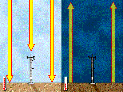
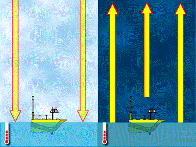
Both the land surface and the water surface absorb and give off heat. However, the land surface absorbs heat and gives off heat at a faster rate than the water. As you can see from the above picture, the land surface heats up fairly quickly during the day but loses much of its heat at night. This decreases the temperature at night. The ocean, however, heats up more slowly during the day than the land does and it also keeps most of its heat at night. Thus the ocean is warmer than the land at night. Those that live near the ocean can test this rather easily. If you go to the beach during a hot summer day, you will notice that the sand may be too hot to walk on without shoes, but the water will be cool enough to swim in. However, if you return to the beach later that night, the sand will be cool but the water will be very warm in comparison. This is because the land surface has radiated its heat into the air above it while it is taking the water surface a much longer time to do likewise.
Characteristics of Hot Air and Cold Air
When air is heated, the air molecules gain energy. As a result of the energy gain, the molecules start to "move around". As they move around, there are less of them in a particular place at any one particular time. Therefore, because of the decreased number of warm air molecules in a particular place at a particular time, the air pressure or the weight of the warmer air is less than if the air were cooler. Suppose there were 100 air molecules in a cup and each molecule weighed 1 gram. The weight of the air in that cup would then be 100 grams (100 x 1 = 100). Now, suppose the sun heated the air molecules in the cup so that 25 of the molecules float away and 75 molecules remain in the cup. The weight of the air molecules in the cup would now be 75 grams (75 x 1 = 75). Because of the heat of the sun, 25 air molecules have floated out of our cup of air. As a result of the decreased numbers of air molecules in our cup, the weight of the air in our cup has decreased.
Now that we know the basics, can you explain how sea breezes occur?